![[ First Gold Rush Edition! ] Colton's Map of the United States of America, The British Provinces, Mexico, The West Indies and Central America . . . 1849 By Joseph Hutchins Colton](https://storage.googleapis.com/raremaps/img/small/101951.jpg)


|
||

|

|
|

|
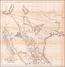
Including A Massive Configuration of Texas
Nice example of the first state of Colton's 1850 2-sheet Map of the United States.
Beginning in 1849, J.H. Colton published 3 separately issued maps of the United States, the standard 1-sheet "pocket map edition," the 4-sheet "wall map" edition and this very are 2-sheet version, which was available either in sheets, pocket map format or dissected and laid on linen (as offered here). The three maps offered one of the most up to date and comprehensive views of the United States and most notably, the western portion of the United States, including those areas recently annexed by the United States following the conclusion of the Mexican War in 1846. This same map would be utilized until about 1860 and, among other notable appearances of the map, the 1854 edition would be bound in two sheets into Andriveau-Goujon's monumental Atlas Choix, a compilation of wall maps and other interesting maps published in Paris from about 1830 to 1880.
The present map shows a massive California, Oregon Territory, Texas and Nebraska, predating the creation of the first round of smaller territories, which would include New Mexico, Utah, Washington and Kanzas Territories, each formed between 1850 and 1855. The Texas Stovepipe configuration is shown, but the color in southwestern Nebraska Territory (later to become Colorado) is no longer shaded to show the area as part of Texas. Indian Territory appears above Texas, unlike earlier editions.
The elaborate grapevine borders, including 12 vignettes of various places of interest, including Willamette Falls in Oregon, the Capitol Building, an incomplete Washington Monument, Astoria Oregon, Mexicans catching cattle, and the Valley of Connecticut from Roanoke.
The present example is the first 1850 edition. As noted in Streeter (describing the 1849 edition), the map shows 'El Dorado or Gold Region' along the Feather River and includes the Table of Distances. This example also includes of Fremont's route along the Humboldt River and other revisions in California, based upon Fremont.
The 1850 edition is quite rare, this being the first example we have seen on the market.
G. W. & C. B. Colton was a prominent family firm of mapmakers who were leaders in the American map trade in the nineteenth century. Its founder, Joseph Hutchins Colton (1800-1893), was a Massachusetts native. Colton did not start in the map trade; rather, he worked in a general store from 1816 to 1829 and then as a night clerk at the United States Post Office in Hartford, Connecticut. By 1830, he was in New York City, where he set up his publishing business a year later.
The first printed item with his imprint is dated 1833, a reprint of S. Stiles & Company’s edition of David Burr’s map of the state of New York. He also printed John Disturnell’s map of New York City in 1833. Colton’s next cartographic venture was in 1835, when he acquired the rights to John Farmer’s seminal maps of Michigan and Wisconsin. Another early and important Colton work is his Topographical Map of the City and County of New York and the Adjacent Country (1836). In 1839, Colton began issuing the Western Tourist and Emigrant’s Guide, which was originally issued by J. Calvin Smith.
During this first decade, Colton did not have a resident map engraver; he relied upon copyrights purchased from other map makers, most often S. Stiles & Company, and later Stiles, Sherman & Smith. Smith was a charter member of the American Geographical and Statistical Society, as was John Disturnell. This connection would bear fruit for Colton during the early period in his career, helping him to acquire the rights to several important maps. By 1850, the Colton firm was one of the primary publishers of guidebooks and immigrant and railroad maps, known for the high-quality steel plate engravings with decorative borders and hand watercolors.
In 1846, Colton published Colton’s Map of the United States of America, British Possessions . . . his first venture into the wall map business. This work would be issued until 1884 and was the first of several successful wall maps issued by the firm, including collaborative works with D.G. Johnson. From the 1840s to 1855, the firm focused on the production of railroad maps. Later, it published a number of Civil War maps.
In 1855, Colton finally issued his first atlas, Colton’s Atlas of the World, issued in two volumes in 1855 and 1856. In 1857 the work was reduced to a single volume under the title of Colton’s General Atlas, which was published in largely the same format until 1888. It is in this work that George Woolworth (G. W.) Colton’s name appears for the first time.
Born in 1827 and lacking formal training as a mapmaker, G. W. joined his father’s business and would later help it to thrive. His brother Charles B. (C. B.) Colton would also join the firm. Beginning in 1859, the General Atlas gives credit to Johnson & Browning, a credit which disappears after 1860, when Johnson & Browning launched their own atlas venture, Johnson’s New Illustrated (Steel Plate) Family Atlas, which bears Colton’s name as the publisher in the 1860 and 1861 editions.
J.H. Colton also published a number of smaller atlases and school geographies, including his Atlas of America (1854-56), his Illustrated Cabinet Atlas (1859), Colton’s Condensed Cabinet Atlas of Descriptive Geography (1864) and Colton’s Quarto Atlas of the World (1865). From 1850 to the early 1890s, the firm also published several school atlases and pocket maps. The firm continued until the late 1890s, when it merged with a competitor and then ceased to trade under the name Colton.

![(Panoramic photograph) Camp Travis, Tex. 9/8/1918 East Side [WWI Camp Travis, near San Antonio, Texas, African American Troops]](https://storage.googleapis.com/raremaps/img/small/87312.jpg)