|
||

|

|
|

|
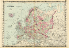
Fantastic General Staff of the Red Army map of Europe from 1941, at a 1:2,500,000 scale, used by a Red Army General Staff Member to chart the development of the Eastern and Western Fronts during the final stages of the Second World War.
The map appears to have been updated from the early stages of the Soviet reconquest of Eastern Europe, with red flags tracking the towns as they came under Allied control. Based on this information, we can conclude that the map was updated until about May 1945, showing, for instance, the Soviet capture of Rostock, Germany, during the Stettin-Rostock Offensive, but not yet showing a flag over Berlin.
The frontlines of both the Eastern and Western Fronts were haphazardly updated over time, with a color scheme that must have been more obvious to the maker than to later readers.
The location of Western front was particularly important to the officers of the Red Army, as they were extremely keen on capturing Berlin before the Allies.
With some of the cities capture by the Red Army, the annotator has gone so far as to label the capturing or occupying units.
![(Second World War - Postwar Reconstruction) [Archive of Materials Related to American Reconstruction Efforts in Bavaria]](https://storage.googleapis.com/raremaps/img/small/88055.jpg)