


|
||

|

|
|

|
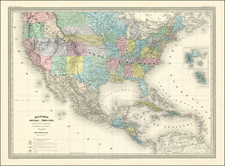
Rare map of the Territory of Nebraska, from Rogers & Johnston's Atlas of the United States.
Rogers & Johnston's map is the only commercial atlas map to show Nebraska Territory on a single map. The map was derived from the monumental and equally rare wall map, an historic collaboration between Professor Rogers, an American, and the Johnston publishing house in Britain.
The map is colored by counties and shows a number of interesting details, including towns, springs, Indian details, topographical information, forts, mountains, etc. The map extends to the Canadian Border and the Rocky Mountains, showing Long's Peak, North Park and Laramie on the western border of the map, along with a number of early explorer's routes. In the north, the course of the Missouri River, Milk River and Yellowstone Rivers are shown in fine detail, along with the various forts in the region.
![[First Map of the Mississippi River] Carte de la decouverte faite l'an dans l'Amerique Septentrionale](https://storage.googleapis.com/raremaps/img/small/93571.jpg)
![(Photograph album) America | Hawaii. 1885. [Photographic album of Hawaii, Yellowstone, Utah, Colorado, and Niagara Falls]](https://storage.googleapis.com/raremaps/img/small/87949.jpg)
![(Colorado Springs Photograph) [Original cabinet card albumen photograph of Tejon Street, Colorado Springs, looking south toward Cheyenne Mountain]](https://storage.googleapis.com/raremaps/img/small/87515.jpg)
![Nouvelle Carte Du Mexique, Du Texas Et D'Une Partie Des Etats Limitrophes . . . 1840 [Proposed Railroads In Texas -- First Appearance of Arizona on a Printed Map]](https://storage.googleapis.com/raremaps/img/small/103480.jpg)