|
||

|

|
|

|
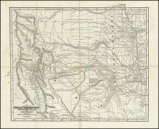
First edition of this large format railroad map of Indian Territory, from Asher & Adams' Atlas of the United States.
Some early township surveys are shown, as are a number of lands ceded to various Indian Tribes. The Atlas was intended as a Railroad Atlas and shows the then existing railroad lines and stations in great detail. One of the earliest obtainable large format separate maps of Indian Territory and the first to appear in a commercial atlas.
Asher & Adams was a New York publishing firm known for their atlases. Notably, their maps were some of the first to prominently exhibit railroad lines, even if this meant a slight reduction in topographical detail. They specialized especially in state and county maps of the United States.
Asher & Adams was a New York publishing firm known for their atlases. Notably, their maps were some of the first to prominently exhibit railroad lines, even if this meant a slight reduction in topographical detail. They specialized especially in state and county maps of the United States.
![[Shows Republic of Texas] United States and Texas](https://storage.googleapis.com/raremaps/img/small/101139.jpg)