|
||

|

|
|

|
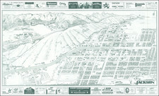
Lively vintage pictorial map of Los Angeles and the surrounding region, issued during World War II as a give-away for soldiers stationed in or passing through Los Angeles.
Prominent locations are identified with small vignettes and include Malibu Beach Colony, Universal City, Fossil Pits, Griffith Park, Lincoln Park, Occidental College, San Gabriel Canyon, Arabian Horse Farm, Rose Bowl, and even the Huntington Library and Art Gallery.
This is an update of the 1937 "Sightseeing Map of Los Angeles" that was issued by the All-Year Club of Southern California. In this edition, the "Homes of the Stars" map has been replaced by maps of Santa Monica, the San Gabriel Valley, and Long Beach.
The map includes a list of facilities for enlisted men, such as U.S.O. clubs, Y.M.C.A.s, etc., as well as facilities for officers, and for servicewomen.
Interestingly, the map notes that California is too crowded for vacationers to come there during the war, but it goes on to say that after the war they will be welcomed.
![Gibraltar to Berlin. [World War II Broadside Map.]](https://storage.googleapis.com/raremaps/img/small/83480.jpg)
![[ First Map of Los Angeles / San Pedro Harbor ] Mouillage De San Pedro](https://storage.googleapis.com/raremaps/img/small/84665.jpg)