


|
||

|

|
|

|
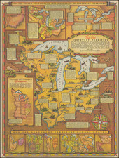
Final? Edition of Rice's Important Map of Minnesota.
Rare 1880 St. Paul-published map of Minnesota, by the state's foremost early map publisher.
The map includes an inset titled "Vicinity of St. Paul, and Minneapolis." The inset shows local train and road routes, covering much of Hennepin and Ramsey Counties.
The map is colored by county and shows Incorporated Cities, Township and Railroad Stations, Post Offices, Completed and proposed railroad lines, and county boundaries. A ridgeline in northern Minnesota notes, "Dividing Ridge between the waters flowing into the Hudson's Bay and the Gulf of Mexico."
The present map should be compared to Rice's 1872 edition to see just how much had changed during the intervening eight years. The 1872 Rice map is closely related to another 1872 map, by A. J. Reed. Rice and Reed originally partnered on an 1871 map of the state, probably the predecessor to the present map, but may have gone their separate ways in 1872. Some sources suggest that this is the year that Reed officially joined Rice's company.
On close examination, it seems that a new lithographic matrix was used for the 1880 map, replacing that which was used in earlier editions. We have not determined at what point the change occurred.
The earliest maps of Minnesota printed in the state were printed circa 1855, but there was very little activity until the mid-1870s. G. J. Rice and Joseph Sewell seem to be the only large-scale commercial mapmakers in Minnesota prior to 1875.
Rarity
The 1880 edition is apparently very rare, with no examples listed in OCLC. It is apparently unrecorded.
OCLC notes examples dated 1871, 1872, 1873, 1875, 1876, and 1877.
![[ Great Lakes - Upper Midwest -- Western Canada ] Partie Occidentale Du Canada, contenant les cinq Grands Lacs, avec Pays Circonvoisons](https://storage.googleapis.com/raremaps/img/small/98377.jpg)
![[Red River Valley] Map of the Wheat Region Red River Valley and adjoining Countries in Dakota and Minnesota Published by A.J. Harwood, Fargo, D.T.](https://storage.googleapis.com/raremaps/img/small/70591.jpg)
![[ Northern Pacific Railroad ] NEW 7-30 GOLD LOAN OF THE Northern Pacific Railroad Co. SECURED BY FIRST MORTGAGE ON RAILROAD AND LAND GRANT. SAFE! PROFITABLE! PERMANENT!](https://storage.googleapis.com/raremaps/img/small/101828.jpg)
