|
||

|

|
|

|
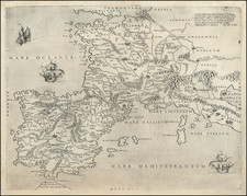
A superlative example of its kind; an 18th-century French manuscript map drawn by a student (possibly a student surveyor or military officer) to demonstrate competence in the art of classical map drafting.
The map incorporates a diversity of components including a classical cartouche with decorative elements, three inset views, multiple methods of rendering topography and ground cover, plans of fortifications and stately homes and gardens, and a city plan. These elements were evidently included in the same composition to show the student's ability to render different kinds of maps as needed.
Although the map was made for practical didactic purposes, there is a kind of fantastical flair to it. The map shows beautiful towns, gardens, and buildings carved from the landscape and intermingled with rivers and mountains.

![(Prussian Octopus) En 1788 Mirabeau disait deja: La Guerre est l’industrie Nationale de la Prusse [Already in 1788 Mirabeau was saying: War is the national industry of Prussia]](https://storage.googleapis.com/raremaps/img/small/76554.jpg)