


|
||

|

|
|

|
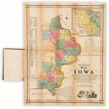
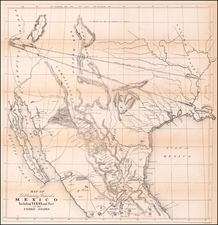
One of the Rarest Early Maps of Iowa
Important early map of Iowa, published by J.H. Colton for John B. Newhall.
The map covers the easternmost part of Iowa, along the Mississippi River, then west to cover Fayette, Buchanan, Linn, Johnson, Washington, Jefferson and Van Buren Counties. The westernmost cities shown are Iowaville on the Des Moines River, and Fairfield in Jefferson County. Iowa City on the Iowa River is also shown.
At the western extremities of the map, the West Boundary of the 1832 Blackhawk Purchase and the West Boundary of the October 21, 1837 Cession are shown, the latter referencing a treaty made at Washington, Iowa Territory, between Carey A. Harris, Commissioner of Indian Affairs, thereto authorized by the President of the United States, and the confederated tribes of Sacs and Foxes, by their chiefs and delegates.
To the west of the 1837 Cession Line, the Sac & Foxes lands are shown, including an Indian Agency and 3 villages on the Des Moines River and Poweshick's Village further north on what would appear to be the Iowa River.
In the upper right corner, a smaller map shows all of Iowa Territory, extending to Canada and the Missouri River in the West, illustrating in red the Cession Lands of 1837, Neutral Grounds and the North Boundary proposed by Governor Robert Lucas, the first Governor of Iowa Territory from 1838 to 1841.
Newhall gives a population table for Iowa Counties in 1838 and 1840, populations of the largest towns in 1840, and distance tables for land and by the Mississippi River.
Newhall's map of Iowa is one of the earliest printed maps to focus on Iowa Territory. The map was incorporated into Newhall's Sketches of Iowa, or The Emigrant's Guide; containing a correct description of the agricultural and mineral resources ... being the result of much observation and travel during a continuous residence of several years. By John B. Newhall, Burlington, Iowa.
Iowa Territory was created by an Act of June 12, 1838. Prior to that dated Iowa was part of Wisconsin Territory.
We are aware of only a few other early Iowa guide books with maps, including:
- Galland's Iowa Emigrant: containing a Map and General Descriptions of the Iowa Territory (1840)
- Williams's A Description of the United States Lands in Iowa (Colton: 1840) (different map)
- Williams's A Description of the Lands of Iowa being a minute description of every section and quarter section, quality of soil, etc (1840)
- Newhall's Sketches of Iowa, or the Emigrant's Guide... (1841)
John B. Newhall
John B. Newhall arrived in Burlington in 1834. John Newhall established a general store with Isaac and Joseph Newhall. The first issue of the Wisconsin Territorial Gazette and Burlington Advertiser of July 27, 1837, included an advertisement for their establishment.
John Newhall was a careful student of the new Territory and was especially interested in the difficulties facing those early pioneers. In 1841, John Newhall published a 252-page volume—Sketches of Iowa, or the Emigrant’s Guide. The book was dedicated to Augustus Caesar Dodge, a delegate to Congress from the Territory of Iowa.
John Newhall published a second volume of one hundred pages, The British Emigrants’ “Hand Book,” And Guide to the New States of America, Particularly Illinois, Iowa, and Wisconsin. This book was published in London in 1844. Newhall had been abroad on a lecture tour promoting his “Sketches of Iowa.” Newhall returned to Iowa and immediately began writing his third book on the Iowa Territory—A Glimpse of Iowa in 1846.
Rarity
The map and guidebook are of the utmost rarity. We locate only 1 copy of the separate map in OCLC (Clements Library, University of Michigan).
The last example of Sketches of Iowa to appear at auction was offered by M & S Books in 1991. The Streeter copy of the book sold for $100 in 1967.
![Comparative Size of Lakes and Islands [Great Lakes, Cuba, Formosa, Ireland, Sicily, Cyprus, Vancouver, Sandwich Islands, Puerto Rico, Corsica, Sardinia, Balearics, Malta, etc]](https://storage.googleapis.com/raremaps/img/small/100135.jpg)