|
||

|

|
|

|
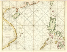
Map of Phuket, Thailand from the Famed Part Six of the Van Keulen Zee-Fakkel - the Secret Atlas of the VOC.
A highly important chart, and the first printed map dedicated to Phuket and Pha Nang Bay. The towns of Phuket ("Puquet") and Patong ("Putom") are marked. The charts covers the bay with the Phi Phi islands and the coast of Krabi. North is to the right, so the chart is oriented with west at the top. Two scales are given, with Dutch and French nautical miles. For safe navigation, many depth soundings are given, as well as markings of shoals and shallow waters.
The chart is exceptionally rare because it only appears in some versions of Part VI of the Zee-Fakkel, known as the secret atlas of the VOC.
The Zee-Fakkel Part VI:
Koeman provides this excellent summary of the VOC Secret Atlas:
The development [ of the van Keulen atlases ] culminated in the publication of Part VI: the famous pilot-guide for the East Indies.
The sixth part of the 'Zee-Fakkel' holds an exceptional position among the atlases published by the House Van Keulen. It contains the descriptions and the charts pertaining to the navigation in East Asian waters, a region where the Dutch held a prominent and envied position; this required a certain secrecy in matters of charts and sailing instructions for the pilots. In the sixth part of the 'Zee-Fakkel', published in 1753, these instructions and charts were given in print for the first time.
Long before 1753, detailed information on the coasts and waters in Asia and the Maleisian Archipelago was only distributed in manuscript form to the pilots of the merchant vessels which sailed from Amsterdam. This information was embodied in the so-called 'Secret atlas of the VOC' (Verenigde Oostindische Compagnie = United East India Company). The charts were kept in the East India House in Amsterdam under custody of the Hydrographer of the VOC.
Several of the charts in the sixth part of the 'Zee-Fakkel' were engraved after the manuscript master-models in the archives of the VOC.
During the period 1726-1755, when Johannes van Keulen II was in office as Hydrographer of the VOC, the first charts for the navigation to the East Indies and in the Malasian Archipelago were engraved. They mark the beginning of what was to become the pilot guide for the East Indies. Gradually, when a policy of secrecy was no longer of use because English and French charts of Asian waters has already appeared in print, more Dutch charts were published. Finally, in 1753, Johannes van Keulen II issued the entire set, provided with a text by Jan de Marre. The splendor displayed in Part VI marks this volume as the most beautiful pilot guide ever published in Amsterdam.
Immediately after 1753, Joh. van Keulen started revision of the work. He added new charts and a final edition with register and numbered plates appeared after his death, ca. 1757. But no edition is known with a date other than 1753 on the title page.
The Dutch produced a remarkable number of enterprising and prolific map and chart makers but not even the Blaeu and Jansson establishments could rival the vigor of the van Keulen family whose business was founded in 1680 and continued under their name until 1823 and in other names until 1885 when it was from wound up and the stock dispersed at auction.
Throughout the history of the family, the widows several of the van Keulens played a major part, after their husbands' deaths, in maintaining the continuity of the business. The firm was founded by Johannes van Keulen who was registered as a bookseller in Amsterdam in 1678. In 1680 he published the first part of his 'Zee Atlas' which, over the years, was expanded to 5 volumes and continued in one form or another until 1734. More ambitious and with a far longer and more complicated life was his book of sea charts, the 'Zee-Fakkel', first published in 1681–82, which was still being printed around the year 1800. A major influence in the development of the firm was the acquisition in 1693 of the stock of a rival map publisher, Hendrik Doncker.
Although the firm was founded by Johannes van Keulen, he was primarily a publisher; it was his son, Gerard, a talented engraver, mathematician, Hydrographer to the East India Company, who became the mainspring of the business which not only published charts but also books on every aspect of geography, navigation, and nautical matters,
It was grandson Johannes van Keulen (II) who in 1753 produced Volume VI of the Zee-Fakkel for the VOC East Indiamen, containing printed charts for the navigation covering the waters from the Cape of Good Hope to Nagasaki . The atlas was not commercially sold and only for use on board of VOC ships, therefore it is also referred to as the 'secret atlas' of the VOC. The engraving quality and craftmanship surpasses that of all earlier printed sea charts.
Sea charts from the secret atlas are among the rarest and most desirable sea charts for collectors.
History of the Exploration of Thailand
The Portuguese explorer Fernão Mendes Pinto arrived in Siam in 1545. His accounts of the country go beyond Ayutthaya and include a reasonably detailed account of ports in the south of the Kingdom as well. Pinto was one of the first European explorers to detail Phuket in his travel accounts. He referred to the island as "Junk Ceylon", a name the Portuguese used for Phuket Island in their maps, mentioning the name seven times in his accounts. Pinto said that Junk Ceylon was a destination port where trading vessels made regular stops for supplies and provisions. However, during the mid-16th century, the island was in decline due to pirates and often rough and unpredictable seas, which deterred merchant vessels from visiting the island. Pinto mentioned several other notable port cities in his accounts, including Patani and Ligor, which is modern-day Nakhon Si Thamarat.
In the 17th century, the Dutch, English and, after the 1680s, the French, competed for the opportunity to trade with Junk Ceylon, which was a rich source of tin. In September 1680, a ship of the French East India Company visited the island and left with a full cargo of tin.
A year or two later, the Siamese King Narai, seeking to reduce Dutch and English influence, named as governor a French medical missionary, Brother René Charbonneau, a member of the Siam mission of the Société des Missions Étrangères. Charbonneau remained as governor until 1685.
In 1685, King Narai confirmed the French tin monopoly in Phuket to their ambassador, the Chevalier de Chaumont.[6]:179 Chaumont's former maître d'hôtel, Sieur de Billy, was named governor of the island.[6]:50 However, the French were expelled from Siam after the 1688 Siamese revolution. On 10 April 1689, Desfarges led an expedition to re-capture Thalang to restore French control in Siam.[17] His occupation of the island led to nothing, and Desfarges returned to Puducherry in January 1690.
The Van Keulens were a family of chartmakers and publishers. The firm, In de Gekroonde Lootsman (In the Crowned Pilot), was founded in 1678 by Johannes van Keulen (1654-1715). Van Keulen originally registered his business as a vendor of books and instruments (specifically cross-staffs). In 1680, however, he gained a privilege from the States of Holland and West Friesland for the publication of pilot guides and sea atlases.
In that year, van Keulen released his Zee-Atlas (Sea Atlas), which secured him a name in the competitive maritime publishing market. In 1681, he published the first volume of Nieuwe Lichtende Zee-Fakkel (New Shining Sea Torch). This would be the first of an eventual five volumes originally published between 1680 and 1684. A sixth volume was added in 1753. The Zee-Fakel won van Keulen lasting fame. The atlas had charts compiled by Claes Jansz Vooght and artwork from Jan Luyken. It proved immensely popular and was reprinted until 1783. There were translations in French, English, Spanish, and Italian.
The late-seventeenth century was an auspicious time to enter the maritime chart business. Previous industry leaders had either closed shop, died, or retired, leaving space for a new competitor. Van Keulen proceeded to buy up the stock and privileges of several maritime publishing firms; the most notable was the stock of Hendrik Doncker, acquired in 1693.
Johannes’ son, Gerard (1678-1726) took over the business upon his father’s death. Gerard was a skilled engraver and mathematician. His talents were noticed, as in 1706 he was named as Hydrographer to the Dutch East India Company (VOC).
In turn, Gerard’s son Johannes II (1704-1770) came to run the shop. He was also tied to the VOC, and his role as their chartmaker allowed his charts to be considered as quasi-official government documents. It is with access to formerly clandestine VOC geographic knowledge that Johannes the Younger was able to add a sixth volume to the Zee-Fakkel, which covered the East Indies. Johannes also continued to sell instruments, including the recently-invented Hadley’s Quadrant from 1744.
When Johannes II died in 1770, his widow ran the business in his stead, aided by her two sons, Cornelis Buys (1736-1778) and Gerard Hulst (1733-1801). Now a century old, the family business had extended to include an anchor factory. After Cornelis died in 1778, Gerard took on the management of the firm alone. He oversaw the introduction of sextants to their inventory and published the Dutch Nautical Almanac beginning in 1788. Annual editions appeared until 1885. Gerard also served as an original member of the Dutch Commission for Longitude at Sea from 1787.
Gerard’s widow ran the business for nine years after his death, when their son, Johannes Hulst, started to lead the firm in 1810. After his death in 1844, the firm passed out of family hands and into the control of Jacob Swert, a skilled cartographer who had worked for the business for two decades. He passed the work to his son, another Jacob, in 1866. By the mid-nineteenth century, the conversion from sail to steam had diminished the size of the market for charts. Fewer sailors needed fewer maps, charts, and instruments. In 1885, after 207 years in business, In de Gekroonde Lootsman closed its doors and auctioned its stock.
![[ First Plan of Bangkok ] Sketch of the Town of Bang-Kok, by a Native.](https://storage.googleapis.com/raremaps/img/small/74889.jpg)