|
||

|

|
|

|
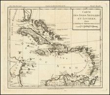
Fine example of this previously unrecorded edition of Herrera's map of Florida and the Caribbean, which first appeared in Herrera's Descripcion de las Indias Ocidentales, first published in Madrid in 1601.
In describing the map, Burden notes:
Of interest to us on this map is the distinctive narrow Florida peninsula. Unlike [Herrera's general map of focusing on North and Central America] some internal detail and nomenclature is given. It contains a relatively accurate delineation of the R. de S. Matheo, St. Johns River, with a large upstream lake. Along with the appearance of Santagustin [San Augustine], it illustrates the presence of the Spanish in Florida since 1565. This is one of the more detailed of Herrera's maps.
In the supplement to Burden's Mapping of North America (Part 2), Burden identifies a rare variant example of the original 1601 map which he identified as having been part of a copy of Historia General de los Hechos de los Castellanos . . . , published in Madrid (1726-1730), which included a complete set of the Herrera maps, including Herrera's general map of Florida and the Caribbean. The differences between the two maps were very subtle, most notably the appearance of two Floridas in the later edition.
First issued in 1601, Herrera's work is one of the most influential works on the New World to be published in the 17th Century.
This edition of the map is very rare on the market.
![[ Florida / Georgia Coastline ] A Plan of Amelia Harbour and Bar, in East Florida, Surveyed by Jacob Blamey, Master of His Majesty's Schooner St. John](https://storage.googleapis.com/raremaps/img/small/38028.jpg)
![[French Colonization in Florida and the Southeast] La Floride Francoise Dressee sur La Relation des Voiages que Ribaut, Laudonier, et Gourgues y ont faits in 1562, 1564 et 1567 . . .](https://storage.googleapis.com/raremaps/img/small/91072.jpg)
![[ Georgia Coast ] Sex alia flumina a Gallis observata. IIII.](https://storage.googleapis.com/raremaps/img/small/97965.jpg)
![[ Florida Native Americans ] Mulierum, quarum maritivel in bello caesi, aut morbo sublati posulata a Rege. XVIII.](https://storage.googleapis.com/raremaps/img/small/98052.jpg)