|
||

|

|
|

|
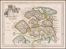
Attractive engraving of Gelderland with the towns of Roermond and Venlo at center. The map is filled with tiny villages, towns, lakes and rivers. Adorned by a decorative strapwork title cartouche and five distance scales.
The county of Gelderland, which became the Duchy of Gelderland at the end of the 12th century, is a former Duchy of the Holy Roman Empire. At the beginning of the 16th century, it was incorporated in the Cercle de Bourgogne and is currently in the Netherlands.
The main cities include Arnhem, Nijmegen, Zutphen, Venlo, Roermond, and Tiel (Thiel).
The Spanish Netherlands
At the death of Duke Charles, and despite the pretensions of his sister, wife of the Duke of Lorraine Rene II, Charles V attributed the duchy to William of Cleves, but took it back in 1543 and integrated it into the Spanish Netherlands. The Spanish Netherlands was the collective name of States of the Holy Roman Empire in the Low Countries, held in personal union by the Spanish Crown (also called Habsburg Spain) from 1556 to 1714.
The Ottens brothers, Reiner and Joshua, operated a successful printing partnership in the mid-eighteenth century (fl. 1726-1765). They began the venture in 1726, publishing maps and other prints as “R & I Ottens.” They specialized in the reprinting of others’ work, especially Guillaume De L’Isle. In 1750, Reiner died; his soon, also Reiner, took his place, but the firm began listing their works as “Joshua & Reiner Ottens.” The firm lasted until Joshua’s death in 1765. Joshua’s widow, Johanna de Lindt, sold their remaining stock of plates in 1784.
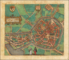
![[Haarlem] Harlemum, sive ut Ha: Barlan Her:lemum Urbs Hollandia famosa . . .](https://storage.googleapis.com/raremaps/img/small/89288.jpg)