|
||

|

|
|

|
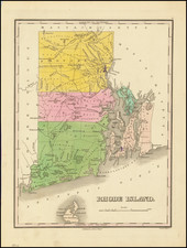
Important early map of Rhode Island, from Carey's American Atlas, one of the earliest separate maps of the state printed in the US. The map is detailed for its time, showing the many counties of this small state. Numerous cities and towns are depicted, with natural features such as rivers and meadows all depicted. Early roads are depicted crisscrossing the state. Topham hill is marked.
This map is based on the surveys of Caleb Harris, which were drawn up by his apparent relative Harding Harris. Their initial map of Rhode Island was first separately published in 1795. The surveying methodology used to create this map is unknown, but standard practice for producing these early state maps was to query prominent individuals in various towns and fill in the remaining information with on-the-ground observations.
An account of the map notes that "Major topographic features are identified, including rivers and streams, ponds, swamps and hills (or what passes for such in Rhode Island)."
Carey published his American Atlas in 1795, which became the first folio atlas published in America. He became the first American publisher to offer hand coloring.
![(Rhode Island Coastal Defenses) [9 Engineering Plans for Barbette Batteries and Related Fortifications]](https://storage.googleapis.com/raremaps/img/small/92401.jpg)