|
||

|

|
|

|
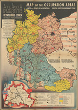
An important persuasive world map, embodying the global outlook of Nazism and the racial philosophy that came to dominate German public discourse in the 1930s. The map advances the idea of German-speaking people from all over the world reuniting. The core idea was based on older romantic nationalist notions promulgated by Friedrich Lange.
The note at the bottom declares that there are around 100 million people in the world who speak German as their mother tongue, that only 67 million of these people reside in the formal German Reich, and it has become all the more important for all Germans to be reunited under one polity.
The map is based on an older map by a German publicist and political activist Friedrich Lange (1852-1917). Lange was a member of a Völkisch movement, which was a racist, populistic, romantic nationalistic, and anti-Semitic movement with its beginnings in the late 19th century. The Nazi movement of the 1930s embraced Lange's ideas and represented them on this poster-map.
The map was published in 1938 by Volksbund für das Deutschtum im Ausland, an organization for Germans abroad, based in Berlin. The organization, which was founded in 1881 and still exists today under the name Verein für Deutsche Kulturbeziehungen im Ausland e. V., was very active in the time of the National-Socialism in Germany and was recruiting countless Germans abroad as spies.
The colors mark German areas and the colonies of the second Reich (red), scattered Germans (Streudeutschtum -dense small red lines), rural (or peasant) Germans (diagonal lines), and Dutch, Flemish and Boers (vertical lines). The red-dashed lines represent German air connections around the world. A full translation of the key follows:
- Geschlossen deutsche Gebiete und Kolonien des Zweiten Reiches [Closed German territories and colonies of the Second Reich]
- Gebiete des Steudeutschtums [Areas of Germandom]
- Bäuerliches Deutschtum [Rural Germandom]
- Niederländisch, flämisch oder südafrikanisch (burisch) [Dutch, Flemish or South African (Boers)]
- Andere Länder [Other countries]
- Frühere deutsche Überseekolonisationen, vgl. Erläuterung rechts [Former German overseas colonizations, cf. Explanation on the right]
- Linien deutschen Uberseeluftverkehrs [Lines of German overseas air traffic]
The two inset maps showcase the languages of Benelux and eastern France (Schriftsprachen und Mundarten im europäischen Nordwesten [written languages and dialects of Northwestern Europe]) and the number of Germans in various m idle European countries(Zahl der Deutschen in Mitteleuropa).
The key in the lower right of the main map lists the German overseas colonies during the Second Reich, which were confiscated after World War I.
Rarity
We could find four institutional copies, all in German libraries.
![[Wall Map of the World] Mappemonde Dressee et Grave Specialement pour Le Petit Journal D’apres les Documents le Plus Regents . . .](https://storage.googleapis.com/raremaps/img/small/70573rd.jpg)