|
||

|

|
|

|
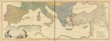
Rare 2-sheet map of the Mediterranean, published by Mortier in Amsterdam.
The map extends from Biscayne Bay and the Straits of Gibraltar in the west to the Black Sea and Cyprus in the east.
Includes 3 large allegorical naval battles, the largest of which shows and engagement between Barbary Pirates and European ships off the coast of North Africa.
Pierre, or Pieter, Mortier (1661-1711) was a Dutch engraver, son of a French refugee. He was born in Leiden. In 1690 he was granted a privilege to publish French maps in Dutch lands. In 1693 he released the first and accompanying volume of the Neptune Francois. The third followed in 1700. His son, Cornelis (1699-1783), would partner with Johannes Covens I, creating one of the most important map publishing companies of the eighteenth century.
![Mappa Maris Mediterranei Fluxus currentes et Naturam Motionum explicans [Map of the flow and motion of the Mediterranean Sea explaining its currents and nature.]](https://storage.googleapis.com/raremaps/img/small/90931.jpg)
![Carte de la Turquie, de l'Arabie et de la Perse, dressée sur les mémoires les plus récents rectifiée par les observations de Messieurs de l'Académie Royale des Sciences par G. de L'Isle, géographe. [Map of Turkey, Arabia, and Persia, drawn up based on the most recent memoirs and corrected by the observations of the gentlemen of the Royal Academy of Sciences by G. de L'Isle, geographer.]](https://storage.googleapis.com/raremaps/img/small/94075.jpg)