|
||

|

|
|

|
The First Topo-Cadastral Map of Natl
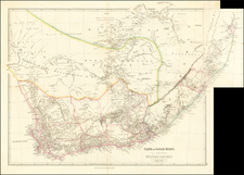
Fine large map of the British Colony of Natal, drawn by Alexander Mair.
The region is divided into divisions, with a fine depiction of the rivers, topographical features, roads, towns, settlements, missions and other features.
This is the first topo-cadastral map of Natal, and one of the best maps of that territory to appear before the turn of the century. Mair based on property maps in the surveyor-general's office. Drawn on a scale of 4 miles to the inch, the was printed in London on four sheets.
All the farms in the colony were shown, with their names. It would appear that Mair was acting surveyor-general of Natal at the time, in the absence of P.C. Sutherland. The map includes the following note:
In publishing this Map the Compiler begs especially to thank P.G. Sutherland Esquire, the Surveyor General for his permission to make reference to all Plans and Documents in the Archives and his Office, and for his able personal assistance. The Compiler also tenders his thanks to The Hon: Theophilus Shepstone, M.L.C.-C.M.G. Secretary for Native Affairs and Dr. R. J. Mann, F.R.A.S. President British Meteorological Society for their kindness in revision the proof.
British Colony of Natal on the Eve of the Anglo-Zulu War
The Colony of Natal was a British colony in south-eastern Africa. It was proclaimed a British colony on May 4, 1843 after the British government had annexed the Boer Republic of Natalia. On May 31, 1910, it was combined with three other colonies to form the Union of South Africa, as one of its provinces. It is currently called the KwaZulu-Natal province of South Africa.
The colony was initially administered from the Cape Colony. The colony's early population growth was driven by settlement from the United Kingdom between 1849 and 1851, which included about 4500 emigrants. Schools were established and various churches began or increased their missionary work in the colony. John Colenso, appointed bishop of Natal, arrived in 1854. In 1856, Natal became a distinct colony with a legislative council of sixteen members, twelve elected by the inhabitants and four nominated by the Crown.
In September 1876, the Colonial Office in the UK received a telegram from Sir Henry Barkly in Cape Town of the imminent collapse of the Transvaal, because the Transvaal's President Burger and his men had been routed after their attack on Sekhukhune and his people, the Pedi. Henry Herbert, 4th Earl of Carnarvon, obtained permission from Benjamin Disraeli to appoint Sir Theophilus Shepstone (known by the Zulu honorific as Somtseu meaning '’father of the nation'’) who had served for 30 years as a Natal administrator, first as Diplomatic Agent to Native Tribes, then as secretary for native affairs, to act as special commissioner to the Transvaal.
In December 1876, Shepstone and 25 troopers from the Natal Mounted Police and others set out from Pietermaritzburg to Pretoria to annex the Transvaal, arriving on January 27, 1877. The British annexation of the Transvaal, was disrupted when Sekhukhune allegedly signed a peace treaty with the Boers, removing the main justification for British intervention. Nonetheless, tensions between the British colonists and the Zulu continued to build, culminating in the Anglo-Zulu War.
Alexander Mair , son of William Mair and his wife Catherine, born Garland, was a sworn land surveyor in Natal.
In 1869 he compiled a "General plan of Vaal Kop and Dadel Fontein", which included several farms with the names of their owners. By 1870 he was city surveyor of Pietermaritzburg.
In 1875 he compiled the first topo-cadastral map of Natal, which was one of the best maps of that territory to appear before the turn of the century. It was based on property maps in the surveyor-general's office. This Map of the Colony of Natal, on a scale of 4 miles to the inch (1:253 440), was printed in London on four sheets. It had relief sketched in, but contained no contours. All the farms in the colony were shown, with their names. It would appear that Mair was acting surveyor-general of Natal at the time, in the absence of P.C. Sutherland*.
Though Mair was listed as absent from Natal in 1880, he later returned and in September 1885 took over the secondary triangulation of the territory from H.D. Laffan*, who returned to the geodetic survey of the Cape Colony.
Mair carried a triangulation into Zululand across the Tugela River as far as Melmoth. His triangulation stations near that town served as basis for the boundary survey carried out by Major McKean at the end of 1886. During 1887-1888 Mair worked mainly in the Umvoti region and the next year wrote a progress report on the survey of Zululand. He was still listed as a land surveyor in Natal in 1890.
He was married to Eliza Adelaide, born Varty (or Varlip), with whom he had a son and a daughter.
![Colton's Africa [Southern Sheet]](https://storage.googleapis.com/raremaps/img/small/98349.jpg)
![[ West Africa ] A Chart of Guinea Describing the Seacoast from Cape de Verde to Cape Bona Esperanca](https://storage.googleapis.com/raremaps/img/small/99962.jpg)