|
||

|

|
|

|
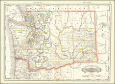
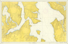
Lively pictorial map of Washington and Oregon, drawn by Antonio Petruccelli.
The map captures the topography of the Pacific Northwest, interspersed with illustrations of fishing, logging, timber, ranching, farming and other local activities, with the occasional image of an Indian locating reservations. Major buildings and public works (Grand Coulee Dam) are also shown, as are other icons and short notes telling he story of the region.
At the top left, a color code gives the relief information in feet.
The verso of the map has text which includes a short article "A Portrait of the Pacific Coast." The text reflects the rapid changes occuring in the region with the opening of the Bonneville Dam in 1938, and the construction work on the Grand Coulee Dam, to open in 1942:
Everyone knows a good deal about California: that it has a Climate, and Yosemite, and San Simeon; oranges, oil, earthquakes, and Hollywood. Therefore, in providing a geographical backdrop for the political drama of the Pacific Coast, FORTUNE presents no more than a skeleton place map of California, and offers a pictorial introduction to the Pacific Northwest - Oregon and Washington. This is no attempt at pictorial statistics. It is a glance at two of the most beautiful U.S. states. Industry in the Pacific states, with the enormous potential waterpower, is just getting off to a good start. And even agriculture, with new lands opened up by irrigation, has a long way to go. Everything, particularly in Washington and Oregon, seems still to have a future - except, possibly, the Chinook salmon, which are in the habit of spawning in the upper tributaries of the Columbia River.
The map was a fold out supplement to the 1940 edition of Fortune Magazine.