


|
||

|

|
|

|
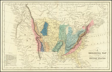
1836 Russian-Language Map Illustrating Russian Claims to California and Oregon.
Fascinating and extremely rare Russian-language maps of the United States and Mexico, published in Saint Petersburg in 1836.
The map is noteworthy for its apparent attempt to show a Russian claim to lands on the West Coast of the present-day United States. The area, which bears the traditional label "New Albion", surrounds the Russian settlement at Fort Ross, shown and labeled here "Кр.: Россъ". On this example of the map, the territory has been hand-colored in green outline (the coloring is original to the publication). The Russian territory stretches from just south of the Columbia River to San Francisco Bay.
The key at the bottom of the map lists the colors of the lands associated with various imperial powers. However, it is not particularly useful; most of the land that would be covered by the key is in the Caribbean, where it has apparently faded or changed color enough to be illegible. The countries from the top left are as follows: England, France, Spain, Netherlands, Denmark, Sweden, and Haiti.
Rarity
The map is very scarce. We have been unable to find any other examples in sales databases, libraries and archives, nor in general online searches.
The map comes from the 1836 edition of Всеобщий атлас или собрание карт всего земного шара, изданный для пользы юношества и сверенный с географиею Арсеньева и других Федором Позняковым. Второе издание, исправленное и дополненное 7 картами, выгравированными г. Фроловым. This translates as The universal atlas or collection of maps of the entire globe. Published for the benefit of youth and verified by the geography of Arsenyev and others by Fyodor Poznyakov. Second revised edition with additional 7 maps engraved by g. Frolov. That atlas was first published in 1829 (with an additional run printed in 1833), then for this second edition in 1836, and again in 1843 as the third edition. The second edition is in neither the RSL nor NLR.
Fyodor Poznyakov (1797-1835) was a Russian military topographer and mapmaker. He began his career in 1822. He supervised the 1825 General map of Asian Russia by the latest division into provinces, regions, and coastal administrations [Generalnaya karta Aziatskoy Rossii po noveyshemu razdeleniyu na gubernii, oblasti i primorskie upravleniya].
Konstantin Arsenyev (1789-1865) was a Russian academic, scientist, topographer, statistics specialist. He was an important figure of his era, held the title of Privy Councillor, was teaching geography to Alexander II - while being an avid advocate of the free peasant labor as opposed to serfdom. Arsenyev also was one of the founders of the Russian Geographical Society. His textbook "Brief General Geography" - first published in 1818 - was the most important textbook on the topic for over 30 years.

![Carte Generale Des Etats Unis De L'Amerique Septentrionale Renfermant Aussi Quelques Provinces Angloise . . . [Shows State of Franklin!]](https://storage.googleapis.com/raremaps/img/small/98580.jpg)
![[Campeche]. Plano del Estado de Campeche 1861. Formado en la Agencia del Ministerio de Fomento en Campeche con vista en su mayor parte de los datos Topográficos é* hidrográficos reunidos por ella y otros datos y noticias que se tuvieron presentes por H. Fremont.](https://storage.googleapis.com/raremaps/img/small/68167.jpg)