|
||

|

|
|

|
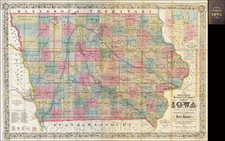
Nice example of the 1853 public survey map of Iowa prepared by Warner Lewis, Surveyor General of Iowa.
The map shows the progress of township and baseline surveys in Iowa.
The northern part of the state is still largely unsurveyed, as is a section west of the Big Sioux River. The south boundary of the Sioux Indian Territory as delineated by Treaty of July 15, 1830 is also shown.
\An explanation in the upper right quadrant explains the various lines on the blocks.
Only a few early cities are named. most of which are near the Mississippi River and tributaries, with Kanesville, Trader's Point and Sargent's Bluff in the west.
The General Land Office (GLO) refers to the independent agency in the United States that was in charge of public domain lands. Created in 1812, it assumed the responsibilities for public domain lands from the United States Department of the Treasury. The Treasury had overseen the survey of the Northwest Territory, but as more area was added to the United States, a new agency was necessary to survey the new lands.
Eventually, the GLO would be responsible for the surveying, platting, and sale of the majority of the land west of the Mississippi, with the exception of Texas. When the Secretary of the Interior was created in 1849, the GLO was placed under its authority. Until the creation of the Forest Service in 1905, the GLO also managed forest lands that had been removed from public domain. In additional to managing the fees and sales of land, the GLO produced maps and plans of the areas and plots they surveyed. In 1946, the GLO merged with the United States Grazing Service to become the Bureau of Land Management.

![[Missouri, Illinois, Indian Territory, Kansas, Nebraska, Iowa] Amer. Sep. No. 49. Partie des États Unis](https://storage.googleapis.com/raremaps/img/small/74904.jpg)