This item has been sold, but you can enter your email address to be notified if another example becomes available.


|
||

|

|
|

|
Stock# 66439
Description
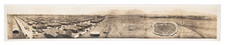
World War II-Era Map of the Hawaiian Islands, With Updates to the Last Months of the War in the Pacific.
Like many Second World War maps of Hawaii, the present chart is based on the June 1940 U.S. Coast and Geodetic Survey map of Hawaii. This is a "Fleet Operating Area Chart" with the green data overprinted as of March 1945, during the final stages of World War II.
The map establishes operating zones, bombing ranges, slick areas, etc. for fleets operating around Hawaii.
The map bears the secrecy rating "RESTRICTED".
The map is U.S.C. & G.S. 4102
Condition Description
Folding map.
![(Second World War - Balkans) Karte von Südosteuropa [Map of Southeastern Europe]](https://storage.googleapis.com/raremaps/img/small/90544.jpg)