|
||

|

|
|

|
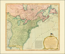
A nice example of the Sayer-Jefferys London issue of Lewis Evans' seminal map of the British Colonies in North America.
Along with the maps of Henry Popple and John Mitchell, Lewis Evans' map is considered among the most important and influential American maps of the 18th Century, and is the only one of the three to have been published by an American. Both Evans and Mitchell's maps were intended to spur western expansion into the Trans-Allegheny, Ohio Valley and regions westward, and in response to French encroachments.
Evans' map provided the best early depiction of the Ohio country, while documenting competing British, French and native American claims in a region destined to be the flashpoint of the French and Indian War. In this regard it is of particular note for treating the Iroquois Confederacy as a geopolitical power in its own right, with its own internal political structure, territory (here known as "Aquanishuonigy") and diplomatic interests.
The map is filled with details meriting closer study. It locates hundreds of European and native American settlements, depicts the network of roads and trails, and provides an immense amount of information about the navigability of rivers and important portages. The many other notations include for example, Dartmouth College, the location of "elephant bones," "Antique Sculptures," salt and limestone deposits, and petroleum in western Pennsylvania and coal in Ohio.
Evans' map became the standard for nearly 50 years, being re-issued by Jefferys, Bowles, Kitchen and others. The map is a milestone both for its political significance and extension of cartographic knowledge in the region. Governor Pownall re-issued an updated edition of the map taken from the original Evans plate, with an addition of New England and a group of tables, naming townships in the Colonies. Pownall had been a great supporter of Evans and pledged the proceeds from the map to Evans' daughter. The cartographic importance of the map and its place in the history of cartography are substantial.
Pritchard and Taliaferro describe Evans as "the best geographer working in the English colonies in the mid-eighteenth century. A dedicated scientist, he exchanged scholarly information with Peter Collinson, Benjamin Franklin, colonial administrator Thomas Pownall, New York mathematician and mapmaker Cadwallader Colden, and others." ( Degrees of Latitude, p. 172) His natural talent, his own extensive surveys in western New York and Pennsylvania, and his large network of fellow scholars and mapmakers enabled him to produce what for its time was an extraordinarily accurate and detailed map. Many compared it favorably to the monumental Map of the British and French Dominions in North America, recently completed by Virginia physician John Mitchell. Benjamin Franklin, for example, wrote that "When [Evans' map] is done, Dr. Mitchel's Map may perhaps be something improv'd from it." ( Degrees of Latitude, p. 174)
The first edition of Evans' map was engraved by James Turner and published in Philadelphia in 1755. It was accompanied by Evans' Analysis of a General Map of the Middle British Colonies, an essay describing the map's sources and explaining its geopolitical significance. The map's importance, and the rarity of the Philadelphia edition, soon led to its being copied and reissued in London many times by the end of the 18th century.
Offered here is the rare John Gibson issue of the map, published by Thomas Jefferys in 1758. The geography on this new edition is more or less faithful to Evans' map, but Gibson introduced numerous long text notes borrowed from Evans' Essays, which combine to give the map a rhetorical impact not present in Evans' prototype. The most pointed of these emphasize the immense potential of the western country and the strategic threat posed by the French. One such note provides
that if the French settle on the Back of our Colonies, the English must either become subject to them in a little Time, or else have their Throats cut & lose all their Slaves; to avoid the latter, 'tis natural to suppose they will be necessitated to submit to the former.
The full title of the map is:
A general Map of the Middle British Colonies in America: Viz. Virginia, Maryland, Delaware, Pensilvania, New-Jersey, New-York, Connecticut and Rhode-Island: Of Aquanishuonigy the Country of the Confederate Indians Comprehending Aquanishuonigy proper, their Places of Residence, Ohio and Thuchsochruntie their Deer Hunting Countries, Couchsachrage and Skaniadarade their Beaver Hunting Countries, of the Lakes Erie, Ontario and Champlain, And of Part of New-France: Wherein is also shewn the antient and present Seats of the Indian Nations; carefully copied from the Original Publish'd at Philadelphia By Mr. Lewis Evans 1755 with some Improvements by I. Gibson.
The map is rare on the market. This is the second example we have offered in the past 20+ years.
Robert Sayer (ca. 1724-1794) was a prominent London map publisher. Robert’s father was a lawyer, but his older brother married Mary Overton, the widow of prominent mapmaker Philip Overton and the proprietor of his shop after his death. Mary continued the business for roughly a year after her marriage and then, in early 1748, it passed to Robert. Robert became a freeman of the Stationers’ Company later that year; his first advertisement as an independent publisher was released in December.
Sayer benefited from Overton’s considerable stock, which included the plates of John Senex. In the 1750s, Sayer specialized in design books and topographical prints, as well as comic mezzotints. In 1753, he, along with John Roque, published a new edition of Thomas Read’s Small British Atlas, the first of several county atlases that Sayer would publish.
Sayer’s business continued to grow. In 1760 he moved further down Fleet Street to larger premises at 53 Fleet Street. In 1766, he acquired Thomas Jefferys’ stock when the latter went bankrupt. In 1774, he entered into a partnership with John Bennett, his former apprentice. The pair specialized in American atlases, based on the work of Jefferys. They also began publishing navigational charts in the 1780s and quickly became the largest supplier of British charts in the trade.
Bennett’s mental health declined, and the partnership ended in 1784. As Sayer aged, he relied on his employees Robert Laurie and James Whittle, who eventually succeeded him. He spent more and more time at his house in Richmond. In 1794, he died in Bath.
Thomas Jefferys (ca. 1719-1771) was a prolific map publisher, engraver, and cartographer based in London. His father was a cutler, but Jefferys was apprenticed to Emanuel Bowen, a prominent mapmaker and engraver. He was made free of the Merchant Taylors’ Company in 1744, although two earlier maps bearing his name have been identified.
Jefferys had several collaborators and partners throughout his career. His first atlas, The Small English Atlas, was published with Thomas Kitchin in 1748-9. Later, he worked with Robert Sayer on A General Topography of North America (1768); Sayer also published posthumous collections with Jefferys' contributions including The American Atlas, The North-American Pilot, and The West-India Atlas.
Jefferys was the Geographer to Frederick Prince of Wales and, from 1760, to King George III. Thanks especially to opportunities offered by the Seven Years' War, he is best known today for his maps of North America, and for his central place in the map trade—he not only sold maps commercially, but also imported the latest materials and had ties to several government bodies for whom he produced materials.
Upon his death in 1771, his workshop passed to his partner, William Faden, and his son, Thomas Jr. However, Jefferys had gone bankrupt in 1766 and some of his plates were bought by Robert Sayer (see above). Sayer, who had partnered in the past with Philip Overton (d. 1751), specialized in (re)publishing maps. In 1770, he partnered with John Bennett and many Jefferys maps were republished by the duo.
Lewis Evans was a land surveyor and map maker who produced one of the most influential American maps of the eighteenth-century, “A general map of the Middle British Colonies” (1755). Evans was born near Pwllheli, Caernarvonshire, Wales and emigrated to the North American colonies in 1731. He found work in Philadelphia as a clerk to no less than Benjamin Franklin, who also published several of his works including the cartographic memoir that accompanied the 1755 map and a 1749 map of Pennsylvania, New Jersey, New York and Delaware. Evans was outspoken and politically active, a combination that landed him in prison in New York for libel against the Governor of Pennsylvania, Robert Hunter Morris. He died there on June 12, 1756, leaving behind a daughter, Amelia.
Amelia’s godmother was Franklin’s wife, Deborah, who raised the girl after Evans’ death. Part of Amelia’s inheritance was the plate of the 1755 map. The rest of his maps and instruments were sold at auction in early 1760. Benjamin Franklin later arranged for the plate to be sent to John Almon for reprinting in an attempt to support Amelia. This resulted in the 1776 Pownall edition of the map; however, sales were not as expected, leaving Amelia short of funds.
![(American Revolution - Spanish Mapping) Mapa Geografico Que Comprehende La Nueva Inglaterra, Nueva York, Nueva Jersey, Pensilvania, Maryland y Parte de Virginia. [Geographic Map Encompassing New England, New York, New Jersey, Pennsylvania, Maryland, and Part of Virginia.]](https://storage.googleapis.com/raremaps/img/small/95136.jpg)
![[ US-Mexico Border Survey: General Order From the President of the United States Directing William H. Emory to lead the US-Mexico Boundary Survey ]](https://storage.googleapis.com/raremaps/img/small/101837.jpg)
![[ American Revolution - Satirical Warning To Dutch Commerce ] Den Door List en Geweld Aangevallen Leeuw.](https://storage.googleapis.com/raremaps/img/small/99580.jpg)