|
||

|

|
|

|
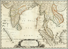
Striking Chart of the Tonkin Bar in the Gulf of Tonkin
Diagramatic, focused plan of the Tonkin Bar, based on early eighteenth-century sketches. The chart shows the entrance of the Song Thai Binh and the Song Van-Uc into the Gulf of Tonkin and was published by Alexander Dalrymple, renowned hydrographer of the East Indies.
These two rivers, Song Thai Binh and Song Van-Uc, and their inland channels and canals gave boat access to Tongking (“Eastern Capital”, now Hanoi; formerly Cachao in the Portuguese rendering of the native Vietnamese), where the East India Company had a factor and a factory for trade.
The chart is deceptively simple in that it includes much empty space. As Dalrymple explains in the first volume of his important collection of charts, the General Collection of Nautical Publications, “Blank Space does not denote that there are no Dangers in that Space; but only denotes that the Dangers in such Space are unknown.”
This minimalism follows the manuscript source material it was based on, observations from John Walsh in 1719. It was meant to be used in conjunction with other charts and plans that Dalrymple had also published in order to offer as complete a picture possible of the hydrography of the area then available.
The entrance to the larger river, at left, is obstructed by two islands. The tidal flow means that the areas near these islands and the shore are often dry when the tide is low, as indicated by notes on the chart. The narrow channel to enter the wider gulf is shown in the map with dotted lines and sounding depths. This area remains quite hazardous today, despite dredging.
A series of hills are included to the east, as they would be seen from the river’s entrance. An inscription in the bottom left explains that these hills were engraved by B. Henry, while the rest of the chart was done by J. Russell. This points to the specificity of work within chartmaking. Benjamin Henry was an engraver who specialized in hill shading, as seen here. Henry also accompanied Dalrymple on his 1775 trip to Madras, where it is likely he died. John Russell engraved several plans for Dalyrmple in his career as a jobbing cartographer and engraver.
The identity of Walsh, however, is more elusive. He was most likely a supercargo on an English East India Company (EIC) vessel. As Dalrymple worked for the EIC at several times in his career, including as their hydrographer, he would have had access to their manuscript charts and journals, as well as his own manuscript collection, which he then compiled and published in various projects.
Publication and states of this chart
This plan was published in 1774, part of Dalrymple’s Plans of Ports in the East Indies. This work, privately published by subscription, was issued in six installments; the EIC alone subscribed for 100 copies. Each installment featured 12-20 port plans; each plan was accompanied by explanatory texts printed on a separate page. The final installment was issued in April 1775.
This plan was first released in October 1774, in the fourth installment. It was printed with an article by Sir Edmund Halley, Fellow of the Royal Society and renowned astronomer (and mapmaker), that had run in the journal of the Royal Society, the Philosophical Transactions (“An account of the course of the tides at Tonqueen in a letter from Mr Francis Davenport, July 15, 1678, with the theory of them, at the Barr of Tonqueen, by the learned Edmund Halley Fellow of the Royal Society”, PT 13 (1684): 677-688).
There are four known states of the Tonqueen Bar plan:
1. Undated with engraved attribution to E. Walsh. Issued in October 1774 with the fourth instalment.
2. Late 1774-early 1775. Has the “Hills by B. Henry” note.
3. Attribution changes to John Walsh and is dated 1719. Made before April 1775.
4. Short lengths of radial line, depending on the crossing of the north-south and east-west engraved lines as their centre, added between the neatline and the solid border. Printed in or after 1779.
The present item is an example of the third state.
Alexander Dalrymple (1737-1808) was a skilled hydrographer. He was born near Edinburgh and was the son of a Member of Parliament. As a teenager, Alexander—the eleventh of fifteen children—began a career with the East India Company (EIC). He worked as a writer for the Company and was posted to Madras in 1753. There, he rose to the position of sub-secretary and researched the English trade with Burma, Indo-China, and Borneo, quickly becoming an expert in Maritime Southeast Asia.
While a Company servant, Dalrymple sailed on three voyages around the Philippines, Borneo, Sulu, and other islands. He was testing hydrographic hypotheses, accessing archives, and making new charts on all of these voyages. In 1763, he resigned from the EIC and began a return trip to London, where he sought to promote a new trading opportunity at Balambangan. On his way home, he was named provisional deputy governor at Manila in April 1764, as the British then held the archipelago.
Back in London, Dalrymple continued to research the geography and hydrography of the South Seas and the East Indies. He published several works, including An Account of the Discoveries Made in the South Pacifick Ocean Previous to 1764 (1767) and An Historical Collection of the Several Voyages and Discoveries in the South Pacific Ocean (1769-71). The former of these made him the Royal Society’s preference to lead the South Pacific leg of the Transit of Venus observations of 1769; the Admiralty preferred a naval officer and chose Lieutenant James Cook instead. In both of these works, Dalrymple championed the hypothesis that there was a massive southern continent counterbalancing the northern continents.
Dalrymple also published many charts at this time, and he continued to lobby for a trade settlement at Balambangan. However, a disagreement with the EIC meant that he was removed from the proposed expedition to the island. In 1774, he began to publish his series of Plans of Ports in the East Indies, complete with sailing directions. Thanks in part to this successful venture, he managed to regain employment with the EIC in 1775, returning to Madras. There, he was ensnared in a scandal involving the Madras council which necessitated his return to London in April 1777.
On the return voyage, Dalrymple used a John Arnold chronometer and became an advocate for renewed and precise calculation of longitude to both signal the best routes during the proper seasons and to revise charts. He convinced the EIC to employ him on correcting their charts and publishing new ones, which he began to do in 1779. In the same year, he proposed a project that would create coastal charts for EIC ships from the Mozambique Channel to China. To this end, Dalrymple began publishing new charts annually. In fifteen years, Dalrymple published 550 plan and charts, 45 plates of coastal views, and nearly sixty books and pamphlets on navigation.
A Fellow of the Royal Society since 1771, Dalrymple was at the heart of a large circle of savants interested in geography. He was a close friend of Joseph Banks, James Rennell (with whom he had sailed in the East Indies), and William Marsden. Dalrymple contributed to the compilation of charts for the Vancouver expedition in the early 1790s, just one sign of his close relations with various branches of the government and the elite.
In 1795, his skills, erudition, experience, and social ties led him to be named as the first head of Britain’s newly-created Hydrographic Office (HO). His main task at this time was to sort the existing chart collection, while also evaluating the charts’ continued utility. By 1800, the HO was also tentatively engraving their own charts, although not performing their own surveying expeditions. While at the HO, Dalrymple proofed over 150 charts, as well as reprinted many of this own EIC plates, which by 1804 numbered 817. In 1806, Dalrymple published his EIC charts and sailing directions together in geographically-themed volumes, the Collection of Nautical Memoirs and Journals.
Things were not all rosy, however, as Dalrymple clashed with officials at the Admiralty over confidentiality of unpublished foreign charts and the direction of the HO. The Board of Admiralty fired him in late May of 1808. He died only three weeks later, on June 19, 1808.
In addition to the hundreds of charts he created in his lifetime, his personal working library was considerable. This library went on to form the core of the Admiralty library and of the HO’s own book collection. The Admiralty also bought over 400 of his copper plates, many of which were re-issued as Admiralty charts.