This item has been sold, but you can enter your email address to be notified if another example becomes available.


|
||

|

|
|

|
Stock# 66402
Description
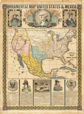
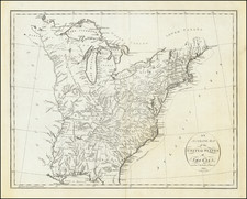
An important political map focusing on the issue of slavery from the pivotal year of the Dredd Scott ruling.
Scarce map of the United States, illustrating the Free and Slave States, along with the Territories of the US, from Rogers & Johnston's Atlas of the United States.
Free states and territories are colored green. The dark green shows the free settled states, and the light green the territories.
Slave-holding states are colored red. The dark red shows the slave importing, and the light red, the states exporting slaves.
Condition Description
Fold split, repaired on verso. Minor offsetting.
![[Eurpean and American Air Routes] TWA Trans World Airline U.S.A. • Europe • Africa • Asia Air Routes](https://storage.googleapis.com/raremaps/img/small/89027.jpg)