


|
||

|

|
|

|
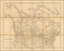
Impressive Canadian Railroad Map Showing the Proposed - But Never Realized - Province of Kewaydin.
Color-lithographed antique folding map of Canada west of Ontario, published in Montreal in 1882 by the Dawson Brothers.
The map features the Province of Kewaydin on the southwest shores of Hudson Bay - carved away from present-day Manitoba.
The map illustrates the course of the Canadian Pacific Railway and other realized and proposed railway lines.
The Province of Kewaydin
The Province of Kewaydin was a proposed province within Canada's northern territories in the mid-1880s. There is little written about the proposal today, and not all that much from contemporary sources either; this is the only map that we can find with Kewaydin shown. The following report covers the proposal of the province and its relationship to border disputes between Manitoba and Ontario: http://peel.library.ualberta.ca/bibliography/1190/9.html
Rarity
We find no examples offered for sale since 1956 (RBH).
![[ Canada / New France Official Report Regarding Return of Fort Bourbon and Dispute with Hudson Bay Company ] May 27, 1699 Report of Louis II Phélypeaux, Comte de Pontchartrain](https://storage.googleapis.com/raremaps/img/small/100562.jpg)
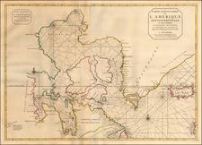
![Carte Du Canada ou de la Nouvelle France et des Decouvertes qui y ont ete faites . . . [Map of Canada or New France and the Discoveries Made Therein . . .]](https://storage.googleapis.com/raremaps/img/small/94450.jpg)
![[ Pacific Northwest - Northwest Passage ] Limes Occidentis Quivira et Anian. 1597](https://storage.googleapis.com/raremaps/img/small/71207.jpg)