


|
||

|

|
|

|
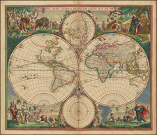
Old hand-color example of Frederick De Wit's striking double hemisphere map of the World, with significantly new cartographic detail in Southeast Asia and to the north of New Zealand.
The map shows the Sanson model of California as an Island.
The brilliant scenes in the corners combine images of the four seasons, the elements and the signs of the zodiac in a well-balanced and natural way. According to Shirley, De Wit's map is one of the most attractive of its time.
This is the new plate of the map that, according to Shirley (451), was issued in the 1680s. The following changes are made:
- Briggs model California as an island (flat top) changed to Sanson model (two fingers at the top)
- The coastline of the Pacific Northwest has been removed.
- Nova Guinea appears in the Western Hemisphere.
- Quiri Regio appears in the Western Hemisphere.
- One large Great Lake has been replaced with a group of open-ended Great Lakes.
- Anian and the Straits of Anian have been removed.
- Far more detail in the interior of North & South America.
De Wit (1629 ca.-1706) was a mapmaker and mapseller who was born in Gouda but who worked and died in Amsterdam. He moved to the city in 1648, where he opened a printing operation under the name of The Three Crabs; later, he changed the name of his shop to The White Chart. From the 1660s onward, he published atlases with a variety of maps; he is best known for these atlases and his Dutch town maps. After Frederik’s death in 1706, his wife Maria ran the shop for four years before selling it. Their son, Franciscus, was a stockfish merchant and had no interest in the map shop. At the auction to liquidate the de Wit stock, most of the plates went to Pieter Mortier, whose firm eventually became Covens & Mortier, one of the biggest cartography houses of the eighteenth century.

![Карта Часовыхъ Поясовъ. [Map of Time Zones]](https://storage.googleapis.com/raremaps/img/small/95040.jpg)
![[ World in Two Hemispheres on Polar Projections ]](https://storage.googleapis.com/raremaps/img/small/99920.jpg)
![[ World Powers - Confrontation or Relaxation? ] Weltmachte-Konfrontation oder Entspannung?](https://storage.googleapis.com/raremaps/img/small/90939.jpg)