


|
||

|

|
|

|
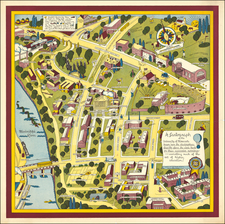
Large lithographed wall map of South Crookston, Minnesota.
The map includes a number of early pencil notes and modifications, extending streets and the location of a proposed bridge.
The town south of the Red Lake River was laid out roughly along the lines of what is shown on the map, though not all streets, blocks, and parks were realized.
One of the notes states "original plat recorded June 15 -8:am 1887.
Crookston
The present-day site of Crookston first saw settlement by non-Indian people around 1872. It was the site of a federal land office by 1876 and sited on a portion of the Great Northern Railway which began operations prior to 1880.
Crookston was incorporated on April 1, 1879, as "Queen City". By the end of that year, the town boasted a jail, graded streets, and a few plank sidewalks. Soon, it was decided that the town needed a new name. Two factions emerged that supported two different names. One group wished to honor the town's first mayor, Captain Ellerey C. Davis, by renaming "Queen City" to "Davis." Another group picked the name Crookston to honor Colonel William Crooks, a soldier, and railroad builder. The present-day name was reportedly chosen by means of a coin toss.
Soon, immigrants from Scandinavia and Germany began populating Crookston. At one point, eight different railroad lines reached Crookston and the town became a center of commerce and manufacturing.
South Crookston was mapped out by Strander Abstract and Investment Company, with C.C. Strander as president and O.W. Peterson as secretary.
It is now home to a campus of the University of Minnesota.
Rarity
Apparently unique. No copies recorded in OCLC or in other sale databases.

![[ St. Paul, Minnesota - Harley Davidson ] Route of the Winter Carnival Grande Parade -- Saturday January 27th. 1940 . . . .](https://storage.googleapis.com/raremaps/img/small/102073.jpg)