|
||

|

|
|

|
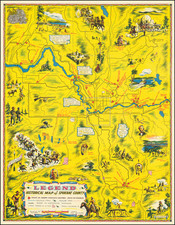
Quirky Pictorial Map of Oregon Used for Forest Fire Prevention and to Celebrate the State's Centennial
Fine and fun pictorial map of Oregon, the Beaver State, filled with historical and contemporary facts and imagery associated with the western state. The map was made as a promotional item for the Keep Oregon Green Association, the oldest continuously operating Keep Green campaign in the United States.
This is a second state of the map, originally issued in 1954 and revised in 1958, just in time for the state’s centennial on February 14, 1959. It was designed by Hugh J. Hayes, an artist responsible for giving the Keep Oregon Green Association its distinctive visual identity. Hayes worked for the campaign in the 1940s and 1950s, creating pamphlets, advertisements, leaflets, envelope art, posters, and, of course, maps.
The map is stuffed with information about the state, including the state flower (Oregon Grape), state bird (Meadowlark), state tree (Douglas Fir), the state seal, and a picture of the capital building. The main industries are highlighted to the right, lumber and agriculture. An elaborate compass rose is in the northeast corner, near a picture of a covered wagon representing the well-known Oregon Trail.
Within the state are important geographic features, like Hell’s Canyon, the Oregon Caves, and Crater Lake. There are also famous events, like the Pendleton Roundup and the Rose Festival, and important cities and towns. Important crops and products are also shown, including apples, pears, wheat, and the world-famous Tillamook Cheese.
An indigenous caricature with a single feather in a headband is used to mark the location of Indian reservations, indicating an important part of the history and heritage of the state. The state’s fraught history with race is also embedded in this map; off the coast is a Spanish galleon with the note, “First white men to see Oregon were Spanish seamen from Mexico in 1543.”
The entire map is green is color, a nod to the campaign it represents. Located near Tillamook and its cheese is another label, “Tillamook Burn.” The Tillamook Burn was a massive forest fire that blazed in 1933, the largest loss of protected acreage in the state’s history. The fire was caused by human carelessness and inspired efforts to prevent forest fires in the future. The Keep Oregon Green campaign was born in 1941; it celebrated its 75th anniversary in 2016, the oldest such campaign still operating in the United States.