


|
||

|

|
|

|
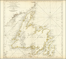
Fine early chart of Newfoundland, based upon the survey work of James Cook, among others.
Attractive large-format map of the entire coast of Newfoundland, a striking testament to Cook's incredible skill as a cartographer. It was the Newfoundland survey which established James Cook's reputation as the pre-eminent naval hydrographer and ultimately led to his being appointed to the command of the Endeavour.
After serving his apprenticeship aboard Whitby Colliers, Cook entered the Royal Navy in 1758, resulting in his charting the St. Lawrence River at Quebec. The need for a Newfoundland survey arose at the conclusion of the Seven Year's War, where the English asserted their fishing rights in the region. French fisherman were allowed limited concessions for catching and curing cod from these rich waters, but to enforce the terms of the Paris Treaty of 1763 new and accurate charts were needed. Cook was selected as master of the Greville in 1764, and the Newfoundland surveys occupied the next three years. His work in the region established for him a well-deserved reputation with the higher authorities.
Thomas Jefferys (ca. 1719-1771) was a prolific map publisher, engraver, and cartographer based in London. His father was a cutler, but Jefferys was apprenticed to Emanuel Bowen, a prominent mapmaker and engraver. He was made free of the Merchant Taylors’ Company in 1744, although two earlier maps bearing his name have been identified.
Jefferys had several collaborators and partners throughout his career. His first atlas, The Small English Atlas, was published with Thomas Kitchin in 1748-9. Later, he worked with Robert Sayer on A General Topography of North America (1768); Sayer also published posthumous collections with Jefferys' contributions including The American Atlas, The North-American Pilot, and The West-India Atlas.
Jefferys was the Geographer to Frederick Prince of Wales and, from 1760, to King George III. Thanks especially to opportunities offered by the Seven Years' War, he is best known today for his maps of North America, and for his central place in the map trade—he not only sold maps commercially, but also imported the latest materials and had ties to several government bodies for whom he produced materials.
Upon his death in 1771, his workshop passed to his partner, William Faden, and his son, Thomas Jr. However, Jefferys had gone bankrupt in 1766 and some of his plates were bought by Robert Sayer (see above). Sayer, who had partnered in the past with Philip Overton (d. 1751), specialized in (re)publishing maps. In 1770, he partnered with John Bennett and many Jefferys maps were republished by the duo.
![[ English Plantations in North America ] A New Map of the most Considerable Plantations of the English In America Dedicated to His Highness William Duke of Glocester.](https://storage.googleapis.com/raremaps/img/small/98233.jpg)
![[ Discovery of the Northwest Passage ] Chart Showing the Recent Search for a North-West Passage. Also the Coast Explored in Search of Sir John Franklin between the Years 1848 and 1854](https://storage.googleapis.com/raremaps/img/small/101874.jpg)