


|
||

|

|
|

|
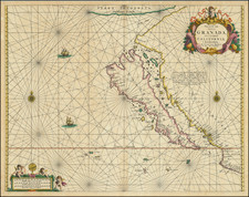
The First Folio Map Devoted To The Island of California
Fine example of Johannes Van Loon's extremely rare sea chart centered on the Island of California.
Van Loon's map is one of the best and most sought after illustrations of the island of California and one of only a few large format maps to focus on the feature. It is also one of the first sea charts of the island, and by far the rarest for collectors.
Issued in the same year as Peter Goos's map of the same title, Burden notes that
it has not been proven which appeared first, but it is believed that the van Loon most probably takes pride of place. This is because the van Loon atlas was the more innovative of the two, while Goos largely drew upon existing charts. Many authorities have applied the date 1661 to its first appearance. However, it is not known to be present in any earlier edition [of Van Loon's Atlas] than that of 1666.
The chart is half filled with the Pacific Ocean, which is criss-crossed with rhumb lines and dotted with two compass roses and two ships in full sail. In the lower left is the scale which is framed by three putti and an armilllary sphere. In the upper right corner is the title cartouche, topped by a cherub surrounded by floral garlands and an ornate frame.
California is shown on the second Sanson model, otherwise known as the Fox form. To the north is a large island with an open border to the west, perhaps denoting that it could be a continent. It is labeled as “Terra Incognita”, with the Dutch equivalent, “Onbekendt Landt”, below. Separating this unknown land from the North American mainland is the Strait of Anian.
Anian derives from Ania, a Chinese province on a large gulf mentioned in Marco Polo’s travels (ch. 5, book 3). The gulf Polo described was actually the Gulf of Tonkin, but the province’s description was transposed from Vietnam to the northwest coast of North America. The first map to do so was Giacomo Gastaldi’s world map of 1562, followed by Zaltieri and Mercator in 1567. The Strait then became shorthand for a passage to China, i.e. a Northwest Passage. It appeared on maps until the mid-eighteenth century.
Van Loon chooses to call the mainland Nova Granada, as opposed to New Spain. California contains several recognizable toponyms, including San Diego (“P. de S. Diego”), P. de Monte Rey, Drake's Bay (“P. de S. Francisco Draco”), Cape Mendocino, Point Reyes, Point Conception, Santa Barbara Channel, Catalina Island, etc. However, all are placed incorrectly relative to their actual positions.
Van Loon's chart also includes a long note, not in the Goos, which has been copied from Jansson's map of North America from 1636.
California a prioribus Geographis semper habita suit quaedam pars continentis: at capta per Hollandos ab Hispanis tabula quaedam Geographica, compertum est, insulam else et continere, ubi latissima est, 500 leucas. A. Cap Mendocino vero usque ad c. S. Lucae repertum testibus tabulae praedita et Francisco Gaulo extendi in longitudinem 1700 leucarum.
The island of California
From its first portrayal on a printed map by Diego Gutiérrez, in 1562, California was shown as part of North America by mapmakers, including Gerardus Mercator and Ortelius. In the 1620s, however, it began to appear as an island in several sources, including Samuel Purchas’ Hakluytus Posthumus or Purchas his Pilgrimes (1625).
This was most likely the result of a reading of the travel account of Sebastian Vizcaino, who had been sent north up the shore of California in 1602. A Carmelite friar who accompanied him described the land as an island and sketched maps to that effect. Normally, this information would have been reviewed and locked in the Spanish repository, the Casa de la Contractación, but the ship carrying the map and other Vizcaino documents was captured by the Dutch. Prominent practitioners like John Speed, Jans Jansson, and Nicolas Sanson adopted the new island and the practice became commonplace. Even after Father Eusebio Kino published a map based on his travels refuting the claim (Paris, 1705), the island remained a fixture until the mid-eighteenth century.
An essential map for California collectors.
![[ Southwest & Texas ] Le Nouveau Mexique, Avec La Partie Septentrionale De L'Ancien, ou De La Nouvelle Espagne](https://storage.googleapis.com/raremaps/img/small/99395.jpg)

![[English Edition!] Maris Pacifici quod vulgo Mar del Zud](https://storage.googleapis.com/raremaps/img/small/71000.jpg)