|
||

|

|
|

|
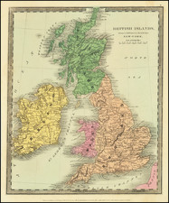
Secret-Rated German Bomber Command Map of the United Kingdom.
Important Secret- (Geheim)-rated overview map, prepared for the Leadership Section of the Nazi Air Force Command (Luftflottenkommando) to illustrate all of the city maps available for planning air raids on the United Kingdom in late 1942.
The footprints of three different kinds of maps are shown on the map: Zielraumkarten (Target area maps) at 1:50,000; Zielraumbildskizzen (Target area image sketches) at 1:25,000; and Verbrauchsskizzen (Consumption sketches?) at 1:25,000.
The map was scarce at the time and is very scarce today - it was Secret-rated and published in an edition of 900. We can find no other copies of the map.
1942 was an interesting time to producing such a map; it followed Germany's decisive defeat in the Battle of Britain in 1940, and came before the deployment of the V-weapons in 1944 and 1945. Earlier in 1942, Germany had launched a series of bombing raids called the Baedeker Blitz. The name derives from Baedeker, a series of German tourist guidebooks, including detailed maps, which were used to generate targets for bombing. The Luftwaffe continued small scale raids throughout 1942, however it suffered great losses at the hands of Great Britain's ever-improving night fighter defenses.
By the end of that year, 3,236 people had been killed, and 4,148 injured, in raids on Britain. However, the strength of the Luftwaffe in the west had drained away, while the RAF had gone from strength to strength, regularly mounting raids of 200 or more aircraft on Germany.

![Newsmap. Monday, November 2, 1942 [on verso:] There Is No All-Purpose Plane](https://storage.googleapis.com/raremaps/img/small/93348.jpg)