|
||

|

|
|

|
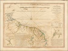
Rare map of French Guiana and St. Lucia, primarily made to promote Louis XV's attempt to colonize French Guiana following the signing of the Treaty of Paris in 1763, which stripped France of virtually all of its colonies in the New World.
This map depicts the coastline between the Maroni River along the western border of French Guiana to the Araguari River, just north of the Amazon River. There is good detail of the rivers, mountains, and settlements in the region.
The map extolls the virtues of the beautiful and fertile lands and the location of native Indians, including one that explains that "this land is very good and is inhabited by the Maures, with whom we are at war." At right are large insets of St. Lucia, incorrectly oriented with the northern end of the island pointing west, and a plan of the city of Cayenne with numerous locations identified by a lettered key.
An extensive description of the region accompanies the map, describing the region, its prospects for settlement, agriculture, fine hard woods, etc. and makes reference to Jean Richer's scientific expedition to French Guiana in 1672.
French Guiana was first visited by Europeans by Christopher Columbus in 1498, on his third voyage. Columbus named it the "Land of pariahs". In 1608 the Grand Duchy of Tuscany did an expedition to the area in order to create an Italian colony for the commerce of Amazonian products to Renaissance Italy, but his sudden death stopped it.
In 1624 France attempted to settle in the area, but was forced to abandon the settlement in the face of opposition from the Portuguese, who viewed the settlement as a violation of the Treaty of Tordesillas. French settlers returned in 1630 and in 1643 managed to establish a settlement at Cayenne along with some small-scale plantations. This second attempt would again be abandoned following Amerindian attacks. In 1658 the Dutch West Indies Company seized French territory to establish the Dutch colony of Cayenne. The French returned once more in 1664, and founded a second settlement at Sinnamary (this was attacked by the Dutch in 1665).
After the Treaty of Paris in 1763, which deprived France of almost all her possessions in the Americas other than Guiana and a few islands, Louis XV sent thousands of settlers to Guiana, who were lured there with stories of plentiful gold and easy fortunes to be made. Instead they found a land filled with hostile natives and tropical diseases. One and a half years later only a few hundred survived. These fled to three small islands which could be seen off shore and named them the Iles de Salut (or "Islands of Salvation"). The largest was called Royal Island, another St. Joseph (after the patron saint of the expedition), and the smallest of the islands, surrounded by strong currents, Île du Diable (the infamous "Devil's Island"). When the survivors of this ill-fated expedition returned home, the terrible stories they told of the colony left a lasting impression in France.
Rarity
The map is of the utmost rarity. We located reference to the map in a French-Portuguese Boundary Dispute Arbitration, referencing the publication date of the map as 1763 and the maker as Beteow, however, we have been unable to locate any copies of the map in a bibliographic sources.
We previously sold and example of this map to the John Carter Brown Library in 2014.
![[El Dorado] Guaiana](https://storage.googleapis.com/raremaps/img/small/97225.jpg)
![[ Curacao / Aruba / Bonaire / Venezuela ] Pas-kaart vande zee custen van Venecuela met dye Bylegende Eylanden . . .](https://storage.googleapis.com/raremaps/img/small/99928.jpg)
![[Heighted with Gold] Pascaert Vande Caribes Eylanden](https://storage.googleapis.com/raremaps/img/small/91150.jpg)