
The item illustrated and described below is sold, but we
have another example in stock. To view the example which
is currently being offered for sale, click the
"View Details" button below.


|
||

|

|
|

|
Stock# 66195
Description
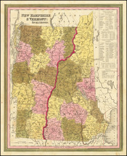
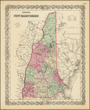
Nice example of Tanner's map of New Hampshire and Vermont, hand colored by counties, and showing towns, roads with distances, railroads, and a host of other details.
The key shows counties and towns in each state, with populations, and populations on a decade by decade basis since 1790. Tanner's maps rarely appears on the market. A nice wide margined example.
![[Colonial New Hampshire Map on Sheepskin] A Plan of a Tract of Land called Monadnock Number six, 1768, Measured according to an agreement with Thomas Packer, Esq. as Follows...](https://storage.googleapis.com/raremaps/img/small/17048.jpg)
![[ Bennington, Vermont ] Position of the Detachment under Lieut. Col.l Baum, at Walmscock near Bennington Shewing the Attacks of the Enemy on the 16th. August 1777. Drawn by Lieut.t Durnford Engineer. Engraved by Wm. Faden 1780](https://storage.googleapis.com/raremaps/img/small/98001.jpg)