|
||

|

|
|

|
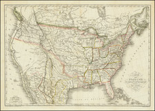
Rare Colton Railroad Map of the United States
Highly detailed railroad map of the United States, issued by GW & CB Colton.
The main map extends to Texas, Dakota, Nebraska, Kansas and Indian Territory.
Completed railroad lines are shown with solid lines, identifying the various railway stations along each line, with proposed lines under construction shown by dashed lines.
The large inset (17 x 13 inches) shows the railroad lines in the west.
Rarity
The map is very rare. OCLC locates an 1870, 1872 and 1881 edition of the map, but no example from 1876.
G. W. & C. B. Colton was a prominent family firm of mapmakers who were leaders in the American map trade in the nineteenth century. The business was founded by Joseph Hutchins Colton (1800-1893) who bought copyrights to existing maps and oversaw their production. By the 1850s, their output had expanded to include original maps, guidebooks, atlases, and railroad maps. Joseph was succeeded by his sons, George Woolworth (1827-1901) and Charles B. Colton (1831-1916). The firm was renamed G. W. & C. B. Colton as a result. George is thought responsible for their best-known work, the General Atlas, originally published under that title in 1857. In 1898, the brothers merged their business and the firm became Colton, Ohman, & Co., which operated until 1901, when August R. Ohman took on the business alone and dropped the Colton name.

![United States of America [with] The Course of the River St. Laurence from Lake Ontarion to Manicouagan Point](https://storage.googleapis.com/raremaps/img/small/71643.jpg)