


|
||

|

|
|

|
Stock# 66119
Description
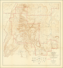
Rare Early Automobile Road Map of Utah
Scarce map of the state of Utah, published by Clason for the Utah Bureau of Immigration, Labor and Statistics.
The map shows County Seats, County Boundaries, Townships Unsubdivided and National Forest Boundaries.
The Transcontinental Auto Roads and Local Auto Roads are noted in Green.
Includes topographical details, Indian Reservations (in red), etc.
![Mexique par Th. Duvotenay…1842 [Republic of Texas]](https://storage.googleapis.com/raremaps/img/small/93713.jpg)
![[ Upper California ] Map of the Californias By T.J. Farnham](https://storage.googleapis.com/raremaps/img/small/99592.jpg)

![Birds-Eye View of Salt Lake City, From the North, Looking South-East, Utah, 1875. [Cabinet card version.]](https://storage.googleapis.com/raremaps/img/small/92362.jpg)