
This item has been sold, but you can enter your email address to be notified if another example becomes available.


|
||

|

|
|

|
Stock# 66108
Description
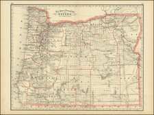
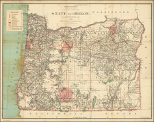
Fine unfolded example of this early map of the state of Oregon, prepared by the US General Land Office.
Includes township surveys to date, Indian Reservations, Indian Treaty details, towns, rivers, lakes, mountains, forts, Surveyor General's Office, US Land Offices, County Seats, and Military reservations.
One of the best large format maps of Oregon published during the period.
![[Washington & Oregon] Amer. Sep. No. 38. Partie Des Etats-Unis](https://storage.googleapis.com/raremaps/img/small/93549.jpg)
![[California / Washington / Oregon] Pacific Highway Maps](https://storage.googleapis.com/raremaps/img/small/89058.jpg)
![[Alaska to San Diego and San Qunitin, British Columbia] A Chart Shewing Part of the Coast of N.W. America, with the Tracks of His Majesty's Sloop Discovery and Armed Tender Chatham . . . (First Modern Map of the West Coast of North America)](https://storage.googleapis.com/raremaps/img/small/102067.jpg)
![[ Used by '49ers To Travel To California ] Map of Oregon and Upper California from the surveys of John Charles Fremont and others authorities drawn by Charles Preuss 1848](https://storage.googleapis.com/raremaps/img/small/100557.jpg)