This item has been sold, but you can enter your email address to be notified if another example becomes available.


|
||

|

|
|

|
Stock# 66097
Description
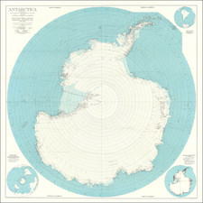
Very detailed map of the south polar regions, illustrating the great precision of Stieler's work.
Remarkable amount of explorer details, including:
- Cook 1772-75
- Bellinghausen 1819-21
- Wedell 1822-23
- Biscoe 1830-32
- Kemp 1834
- Ballen 1839
- D'Urville 1838-40
- Wilkes 1839-40
- Ross 1840-43
- Moore 1845
- Nares 1874
The map is ringed with more than a dozen inset maps, showing mostly Islands in the southern most part of the hemisphere.

![Navigatio ac Itinerarium Iohannis Hugonis Linscotani in Orientalem Sive Lusitanorum Indiam... [Voyage and Journey of Jan Huygen van Linschoten to the Eastern, or Portuguese India...]](https://storage.googleapis.com/raremaps/img/small/93009.jpg)
![[Heightened with Gold] Paskaert Zynde de Noordelijckste Zeekusten van America van Groenland door de Straet Davis en de Straet Hudson tot Terra Neuf . . .](https://storage.googleapis.com/raremaps/img/small/93148.jpg)