The item illustrated and described below is sold, but we
have another example in stock. To view the example which
is currently being offered for sale, click the
"View Details" button below.


|
||

|

|
|

|
Stock# 66065
Description
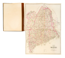
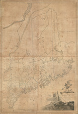
Marvelous example of Tanner's map, from the last edition of Tanner's Universal Atlas.
The map is hand colored by counties, and shows towns, roads with distances, railroads, and a host of other details. The key shows counties and towns in each state, with populations, and populations on a decade by decade basis since 1765. Primitive early northern counties are still incomplete.