|
||

|

|
|

|
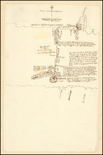
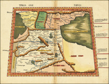
The First Printed Map Based Upon the Projections of the Ancient Greek Geographer, Marinus of Tyre
Nice example of Francesco Berlingheri's map Cyprus, the Holy Land and Middle East, from his Septe Giornate della Geographia di Francesco Berlinghieri (the seven days of Geography), published in Florence in 1482.
The map illustrates one of the greatest of the Ptolemy errors, the belief that a southern continent existed, which counter-balanced the weight of the land-masses in the northern hemisphere, to keep the earth stable on its axis. The present map illustrates a portion of the landlocked Indian Ocean, including much of the Indian Ocean (Indicum Mare), as it had been mapped by Ptolemy. As noted by Suarez:
. . .After crossing east of the Ganges (whose Delta is on the left), we enter Aurea region, a kingdom of gold, which is roughly located where Burma begins today. Above it lies Cirradia, from where, Ptolemy tells us, comes the finest cinnamon. Further down the coast one comes to Argentea Regio, a kingdom of silver, "in which there is said to be much well-guarded metal." Besyngiti, which is also said to have much gold, is situated close by. The region's inhabitants are reported to be "white, short, with flat noses." Here the Temala River, because of its position and because it empties through a southerly elbow of land, appears to be the Irrawaddy. If so, the Sinus Sabaricus would be the Gulf of Martaban, whose eastern shores begin the Malay Peninsula, and the Sinus Permimulicus would be the Gulf of Siam.
That active commerce was conducted between Malaya and points west during the period in which the Geographia was compiled is suggested by the Geographia's reference to the Indian port of Alosygni (probably in the Dodvari Delta) as a "place of embarkation for those who sail for the Golden Chersonense." The Golden Chersonese is generally accepted to be Malaya, which Ptolemy considered and important place . . .
[The Golden Cheronesus] may in fact be Sumatra, portrayed here without the strait that separates it from Malaya. If this is so, it would explain both the shape of the Malay Peninsula and also its extension into the Southern Hemisphere. During the Renaissance, this observation led some scholars (including Abraham Ortelius) to argue that Malaya and Sumatra were once joined in some earlier geological age, rather than conclude that Ptolemy was simply unaware of the Malacca Strait. . . .
Many of the coastal cities in Ptolemy's Southeast Asia are marked as "emporiums." These include the ports of Baracura, Barabonna, and Bsyga, in the region of what would now be Burma. Further along the Malay Peninsula one comes to the Emporium of Tacola, with Sabana at the southernmost tip, in the position of modern day Singapore. Scholars have tried to identify these places, but there is no convincing consensus. The Sinus Perimulicus is probably the Gulf of Siam (if not the Sinus Magnus), with Regio Lestoru being lower Siam and Cambodia. A spine of mountains running north from there, in what is now northern Thailand and Burma, is according to Ptolemy, a "habitat of tigers and elephants," as well as "lions and robbers and wild men who live in caves, having skins like the Hippopotamus, who are able to hurl darts with ease."
In the waters west of the peninsula, in the relative position of the Nicobar Islands, we find Bazacata Insula, where there "are many shellfish, and the inhabitants of the island," who are called Agmatae, "are said at all times to go without clothing." In 673 A.D. the Chinese pilgrim I-Ching . . . reached what he called the "Kingdom of the Naked People," which has been identified as the Nicobars . . .
In the mid-sixteenth century, Gerard Mercator wrongly determined that Bazacatga was actually the Philippine island of Palawan. This was a logical conclusion for Mercator, because he mistakenly believed Taprobana to be Sumatra (rather than Ceylon). . . .
Francesco Berlingheri
While Berlingheri's map is the third map of the region (pre-dated by editions of 1477 (Bologna) and 1478 (Rome)), his map is of the highest importance for several reasons. First, the map is based upon the projections of Marinus of Tyre, a second century AD Greek geographer, cartographer and mathematician, who is credited as the founder of mathematical geography, a system which would have been employed by Claudius Ptolemy at the time Ptolemy originally constructed his Geographia.
Berlingheri's map is also unique in that it is the first printed map of the region to utilize a style which is notably different from the Nicholas Germanicus model and to adopt a different means for projecting the printed landmasses represented on the maps. The maps were engraved by Niccolò Tedesco, a German printer (employing Marinus of Tyre's equidistant meridians and parallels). The maps also have rectangular borders rather than the trapezoidal borders employed in the earlier Bologna and Rome editions (and also the Ulm edition of 1482-1486).
The maps are also believed by some experts to be the earliest cartographic work of Francesco Rosselli, the most important Florentine mapmaker of the late 15th and early 16th Centuries.
Francesco Berlinghieri (1440-1501), was a Florentine engraver. Nicolas Laurentii published Berlinghieri's edition of Ptolemy, which was written in Italian terza rima, comprising 123 folios of text and 31 engraved maps. The work was first printed in 1482, but most surviving examples come from the edition of 1486, which was the first edition to include red printing in the title page. The full title is Geographia. In Questo Volume Si Congengono Septe Giornate Della Geographia Di Francesco Berlingeri Fiorentino Allo Illustrissimo Federigo Duca . . .
Berlinghieri's edition of Ptolemy is unique, in that it includes 31 maps covering Europe, northern Africa and the south part of Asia and is the first atlas to attempt the introduction of modern geography, with the inclusion of four new maps - France, Italy, Spain and Palestine, which are based on contemporary knowledge, rather than a strict plotting of Ptolemy's coordinates. A number of other maps in the Berlinghieri edition of Ptolemy include data which is drawn from modern sources, albeit more subtly so, in part because of transcription errors and in part because of corrections made over time by later scholars.
While Berlinghieri's atlas was the third Italian printed edition of Ptolemy, it was very important in other respects. Berlinghieri's Ptolemaic regional maps are drawn on Marinus' plane projection; and although not generally considered an edition of Ptolemy, the maps are the only examples of Ptolemy's maps to be drawn on the original projection, with equidistant meridians and parallels. Berlinghieri's work was also the first to include a printed Gazetteer for each of the maps. The text by Berlingheiri is a metrical paraphrase of Ptolemy, the first atlas in the Italian language.
Francesco Berlinghieri was an Italian scholar and humanist. He promoted the value of classical Greek learning and therefore was the first to print an edition of Ptolemy in vernacular Italian, rather than Latin.
The maps in Berlinghieri's Geographia, appear distorted as compared to modern maps, because Ptolemy's data was inaccurate. One reason is that Ptolemy estimated the size of the Earth as too small: while Eratosthenes of Cyrene, a Greek mathematician, elegiac poet, athlete, geographer, and astronomer, made several discoveries and inventions including a system of latitude and longitude and conceived the idea of 700 stadia for a degree on the globe, in the Geographia Ptolemy uses 500 stadia. It is not certain if these geographers used the same stadion, but if we assume that they both stuck to the traditional Attic stadion of about 185 meters, then the older estimate is 1/6 too large, and Ptolemy's value is 1/6 too small. Because Ptolemy derived most of his topographic coordinates by converting measured distances to angles, his maps get distorted. So his values for the latitude were in error by up to 2 degrees. For longitude this was even worse, because there was no reliable method to determine geographic longitude.
Ptolemy was well aware of this. It must be added that his original topographic list cannot be reconstructed: the long tables with numbers were transmitted to posterity through copies containing many scribal errors, and people have always been adding or improving the topographic data: this is a testimony to the persistent popularity of this influential work in the history of cartography.
As early as 1938, Arthur M. Hind, Keeper of Prints and Drawings at the British Museum, hinted that the engravings might have been made by Francesco Rosselli, the principal engraver in Florence in the 1480s and 1490s. Subsequently, this possibility was rejected by Roberto Almagia, R. A. Skelton and Tony Campbell. However, both stylistic and circumstantial evidence argues that Rosselli was indeed the engraver, and that this first major commission launched the career of the greatest Florentine map engraver of the period.
Rarity
The map is rare on the market. The last example in a dealer or auction catalog was offered by Richard Arkway in 2008.
Francesco Berlinghieri (1440-1501) was a Florentine engraver. Nicolas Laurentii published Berlinghieri's edition of Ptolemy, which was written in Italian terza rima, comprising 123 folios of text and 31 engraved maps. The work was first printed in 1482, but most surviving examples come from the edition of 1486, which was the first edition to include red printing in the title page. The full title is Geographia. In Questo Volume Si Congengono Septe Giornate Della Geographia Di Francesco Berlingeri Fiorentino Allo Illustrissimo Federigo Duca . . .
Berlinghieri's edition of Ptolemy is unique, in that it includes 31 maps covering Europe, northern Africa and the south part of Asia and is the first atlas to attempt the introduction of modern geography, with the inclusion of four new maps - France, Italy, Spain and Palestine, which are based on contemporary knowledge. rather than a strict plotting of Ptolemy's coordinates. A number of other maps in the Berlinghieri edition of Ptolemy include data which is drawn from modern sources, albeit more subtlely so, in part because of transcription errors and in part because of corrections made over time by later scholars.
While Berlinghieri's atlas was the third Italian printed edition of Ptolemy, it was very important in other respects. Berlinghieri's Ptolemaic regional maps are drawn on Marinus' plane projection; and although not generally considered an edition of Ptolemy, the maps are the only examples of Ptolemy's maps to be drawn on the original projection, with equidistant meridians and parallels. Berlinghieri's work was also the first to include a printed Gazetteer for each of the maps.
The text by Berlingheiri is a metrical paraphrase of Ptolemy, the first atlas in the Italian language. Francesco Berlinghieri was an Italian scholar and humanisrt. He promoted the value of classical Greek learning and therefore was the first to print an edition of Ptolemy in vernacular Italian, rather than Latin. The maps look distorted as compared to modern maps, because Ptolemy's data was inaccurate. One reason is that Ptolemy estimated the size of the Earth as too small: while Eratosthenes of Cyrene, a Greek mathematician, elegiac poet, athlete, geographer, and astronomer, made several discoveries and inventions including a system of latitude and longitude and conceived the idea of 700 stadia for a degree on the globe, in the Geographia Ptolemy uses 500 stadia. It is not certain if these geographers used the same stadion, but if we assume that they both stuck to the traditional Attic stadion of about 185 meters, then the older estimate is 1/6 too large, and Ptolemy's value is 1/6 too small. Because Ptolemy derived most of his topographic coordinates by converting measured distances to angles, his maps get distorted. So his values for the latitude were in error by up to 2 degrees. For longitude this was even worse, because there was no reliable method to determine geographic longitude.
Ptolemy was well aware of this. It must be added that his original topographic list cannot be reconstructed: the long tables with numbers were transmitted to posterity through copies containing many scribal errors, and people have always been adding or improving the topographic data: this is a testimony to the persistent popularity of this influential work in the history of cartography..
As early as 1938 Arthur M. Hind, Keeper of Prints and Drawings at the British Museum, hinted that the engravings might have been made by Francesco Rosselli (1448-before 1527), the principal engraver in Florence in the 1480s and 1490s. Subsequently, this possibility was rejected by Roberto Almagiagrave, R. A. Skelton and Tony Campbell. In the author's view, however, both stylistic and circumstantial evidence argues that Francesco was indeed the engraver, and that this first major commission launched the career that eventually made him known to his contemporaries as 'Franciscus rosellus florentinus Cosmographus'.