
This item has been sold, but you can enter your email address to be notified if another example becomes available.


|
||

|

|
|

|
Stock# 66000
Description
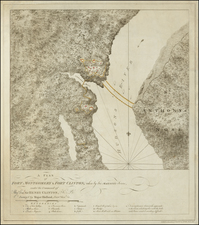
Separately Published Example on Heavy Paper
Detailed sea chart of the area around Plattsburgh, published by the Coast Survey.
The map extends from Cumberland Head to Crab Island and includes a detailed plan of Plattsburgh, along with the surrounding roads, railroads, topographical features, etc.
Includes extensive soundings.
![[ Bennington, Vermont ] Position of the Detachment under Lieut. Col.l Baum, at Walmscock near Bennington Shewing the Attacks of the Enemy on the 16th. August 1777. Drawn by Lieut.t Durnford Engineer. Engraved by Wm. Faden 1780](https://storage.googleapis.com/raremaps/img/small/98001.jpg)