This item has been sold, but you can enter your email address to be notified if another example becomes available.


|
||

|

|
|

|
Stock# 65943
Description
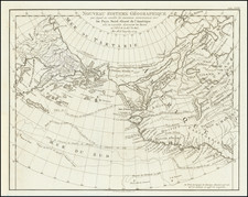
Detailed map of North Polar region, illustrating the great precision of Stieler's work. Many notes regarding explorers routes and many islands and bays in the surrounding insets. One of the best maps of the period.
Observations Stations are underlined in red.
A number of important discoveries are located and dated, as are the routes of explorers in 4 of the most important expeditions, between 1850 and 1874.
![[Spitzbergen & Wiches Lande]](https://storage.googleapis.com/raremaps/img/small/61990.jpg)
![[The Northern and Southern Skies] Hemisphaerii Borealis Coeli et Terrae Sphaerica Scenographia (and) Haemisphaerium Scenographicum Australe Coeli Stellati et Terrae](https://storage.googleapis.com/raremaps/img/small/78919.jpg)