|
||

|

|
|

|
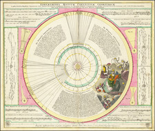
Striking Eighteenth-Century Map of the Stars
Fine old-color example of Conrad Lotter's decorative double polar-hemisphere celestial chart.
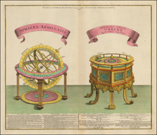
The large hemispheres show the constellations visible in the northern and southern hemispheres. Each circle is filled with pictures of the constellations, forming an illustrated panoply of the heavens. Additionally, there are many educational embellishments surrounding the two main hemispheres. These include two armillary spheres, a celestial and a terrestrial globe pair, as well as several illustrations of astronomical theories.
In the upper right and lower left corners are diagrams of tidal flux and lunar movement in relation to the earth. Most prominent, just under the title at top center, is a model of Ptolemy’s theory of the solar system. The Roman philosopher believed in a geocentric system, where the sun, moon, and all the planets circle the Earth.
Directly below this older model, in the bottom center, is the rival to Ptolemy’s model, which proved correct. This is the theory of Nicolas Copernicus, a heliocentric model that rotates around the sun, with the moon rotating around the earth. Copernicus (1473-1543) developed his ideas in the early sixteenth century, but he waited until the year of his death, 1543, to publish them. He knew they were radical ideas that would face considerable opposition from authorities and the church. Over time, however, savants agreed with Copernicus’ ideas and by the eighteenth-century he was considered one of the most important astronomers in history.
The third model shown here is that of Tycho Brahe (1546-1601), a Danish astronomer, who had a purpose-built observatory constructed for him by King Fredrick II of Denmark. With his calibrated instruments—which did not include a telescope, as that had not yet been invented—he corrected the known positions of the planets out to Saturn, the farthest known planet at that time. However, he did not accept Copernicus’ model entirely. He posited a heliocentric solar system where all the planets orbited the sun except the Earth, which did not move. This theory is illustrated in the upper left corner of this chart.
In the Iower right corner is the theory of Philippe van Lansberge (1561-1632), a Dutch Calvinist Minister, mathematician, and astronomer. His main astronomical work focused on the creation of astronomical tables of celestial movement. His tables allowed contemporaries like Kepler and Galileo to more accurately predict planetary movement, even if van Lansberge did not fully appreciate Kepler’s ideas about elliptical orbit. The illustration shown here is of the earth rotating around the sun, with its characteristic tilt.
This chart is not only aesthetically arresting, but it is also highly informative, summarizing as it does many centuries of astronomical theory and observation.
Tobias Conrad Lotter (1717-1777) is one of the best-known German mapmakers of the eighteenth century. He engraved many of the maps published by Matthaus Seutter, to whose daughter Lotter was married. He took over Seutter’s business in 1756. Lotter’s son, M. A. Lotter, succeeded his father in the business.
![[The April, May & June Sky -- Virgo, Leo, Libra, Leo Minor, Ursa Major, Argo Navis, The Centaur, Hydra, Crater, Curvus Noctus, Boots, Bernices Hair, Asterion . . . ]](https://storage.googleapis.com/raremaps/img/small/87115.jpg)