


|
||

|

|
|

|
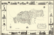
Includes Oklahoma Early City Maps!
Fine large map of Oklahoma, published by the General Land Office in 1914.
The map includes some of the earliest city plans for Oklahoma cities, including:
- Oklahoma City
- Tulsa
- Guthrie
- Muskogee
- McAlester and Vicinity
The map illustrates towns, county boundaries, county seats, Land District Boundaries, National Parks, National Game Preserves, National Forests, Military Reservations and a large Osage Indian Reservation at the top.
The roads and railroads within the state are meticulously given, as are topographical details.
The General Land Office (GLO) refers to the independent agency in the United States that was in charge of public domain lands. Created in 1812, it assumed the responsibilities for public domain lands from the United States Department of the Treasury. The Treasury had overseen the survey of the Northwest Territory, but as more area was added to the United States, a new agency was necessary to survey the new lands.
Eventually, the GLO would be responsible for the surveying, platting, and sale of the majority of the land west of the Mississippi, with the exception of Texas. When the Secretary of the Interior was created in 1849, the GLO was placed under its authority. Until the creation of the Forest Service in 1905, the GLO also managed forest lands that had been removed from public domain. In additional to managing the fees and sales of land, the GLO produced maps and plans of the areas and plots they surveyed. In 1946, the GLO merged with the United States Grazing Service to become the Bureau of Land Management.

![Map of the Missouri Pacific and St. Louis, Iron Mountain and Southern Railway and Connections [Missouri Pacific Railway. St. Louis & All Points East Chair Cars Free Fast Mail Route]](https://storage.googleapis.com/raremaps/img/small/91606.jpg)