


|
||

|

|
|

|
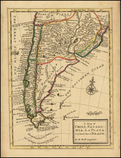
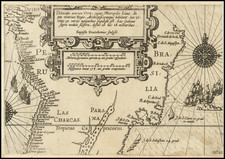
Nice example of Herman Moll's map of the Southern part of South America with Pepys Island, named for Samuel Pepys.
Detailed map showing the southern most part of South America's coastlines with hundreds of harbors, bays and capes.
The Strait of Magellan is mapped in detail. Discovered in 1520 by the Portuguese sailor Ferdinand Magellan, the first explores circumnavigate the globe, this natural channel linking the Atlantic and Pacific Oceans though a challenging route to navigate -given the unpredictable winds and currents-, is the fastest connection between the two oceans. To the east of Terra del Fuego, Moll notes 'Bouwers Land.' This is most likely modern day Isla de los Estados or Staten Island, named after Hendrick Brouwer who recorded the sighting of the island in 1643.
Moll notes a speculative land mass to the west of Chile called 'Davis' Land' or Terre de Davis. Located roughly where Easter Island is today, Terre de Davis or Davis' Land was supposedly discovered in 1688 by an English navigator of the same name. Many historians argue whether or not Davis Land was actually Easter Island, but it does seem likely.
Living and working in London as an engraver and cartographer, Herman Moll (c.1654-1732) spent some of his free time in the London Coffee Houses, socializing with some of the foremost navigators, explorers and buccaneers of his time, who supplied him with surveys and sketches taken from their voyages, such as Capt. William Cowley who kept a journal of his round-the-world trip during 1683-1688, Capt. Woodes Rogers (1679-1732) a buccaneer in the South Seas, and Capt. William Dampier (1651-1715) who made 3 circumnavigations.
Herman Moll (c. 1654-1732) was one of the most important London mapmakers in the first half of the eighteenth century. Moll was probably born in Bremen, Germany, around 1654. He moved to London to escape the Scanian Wars. His earliest work was as an engraver for Moses Pitt on the production of the English Atlas, a failed work which landed Pitt in debtor's prison. Moll also engraved for Sir Jonas Moore, Grenville Collins, John Adair, and the Seller & Price firm. He published his first original maps in the early 1680s and had set up his own shop by the 1690s.
Moll's work quickly helped him become a member of a group which congregated at Jonathan's Coffee House at Number 20 Exchange Alley, Cornhill, where speculators met to trade stock. Moll's circle included the scientist Robert Hooke, the archaeologist William Stuckley, the authors Jonathan Swift and Daniel Defoe, and the intellectually-gifted pirates William Dampier, Woodes Rogers and William Hacke. From these contacts, Moll gained a great deal of privileged information that was included in his maps.
Over the course of his career, he published dozens of geographies, atlases, and histories, not to mention numerous sheet maps. His most famous works are Atlas Geographus, a monthly magazine that ran from 1708 to 1717, and The World Described (1715-54). He also frequently made maps for books, including those of Dampier’s publications and Swift’s Gulliver’s Travels. Moll died in 1732. It is likely that his plates passed to another contemporary, Thomas Bowles, after this death.
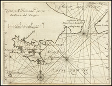
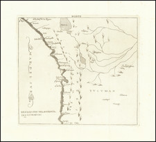
![Segundo Plano de Varios Puertos Del Estrecho de Magallanes, Levantados El Ano De 1786 [Second Plan of Various Ports of the Strait of Magellan, Surveyed in the Year 1786.]](https://storage.googleapis.com/raremaps/img/small/92297.jpg)