|
||

|

|
|

|
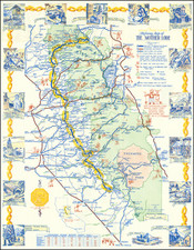
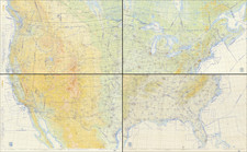
An Iconic Image of Racial Injustice in America
Rare and much studied map of the United States illustrating lynchings in America, prepared using the data compiled by the Tuskegee Institute.
The map has become a much utilized graphic in the study of racial injustice in America, plotting in geographical terms the location of 1,886 lynchings in stark terms. As noted in the Journal of Southern Religion:
The Tuskegee Institute took earlier lists as a basis for research and painstakingly gathered and verified accounts of lynchings for many decades. This dataset became in turn the source of data for both the CSDE data and Project HAL. The Tuskegee Institute, like Wells, aimed to awaken the public conscience by making the extent of lynching visible in their 1931 map, “Lynchings by States and Counties in the United States, 1900–1931.”
Gathering data, preparing charts, and making maps are, as often as not, techniques of statecraft and of nation-building. Yet lynching was an unusual because lynch law lay outside the law of the land. Though lynching was basic to white supremacy, its technical extralegality meant that state and federal governments did not gather data on lynchings. The visibility of the lynch victim was matched by his or her invisibility in the records of the nation-state. . . . lynching was a ritual that made power visible, yet its power depended in part on its lack of visibility in the official records. For Wells and the Tuskegee Institute, to gather and publish the data on lynching made the crime and injustice of lynching as visible as white supremacy. . . .
The work undertaken by the Tuskegee Institute remains in use even in recent years, forming the basis for Google's Equal Justice Initiative (EJI) project, Lynchings in America. https://lynchinginamerica.eji.org/explore. The following is excerpted from the Digital Humanities Quarterly, Vol. 12, #4 (2018)
EJI created an extensive dataset of over 4,000 public lynchings based on work done by Tuskegee University and the research of E.M. Beck and Stewart E. Tolnay that compellingly shows the long legacy of terroristic violence in the American south.
Rarity
It appears that the map survives in a single example held by the Library of Congress.