


|
||

|

|
|

|
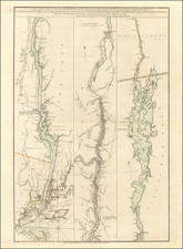
An Atlin Gold Rush Rarity -- The First Map of the Atlin Gold Rush
Finely detailed map of the Atlin Mining District, published in Atlin, British Columbia.
The map provides an excellent overview of the region, centered on Lake Atlin, Taku Arm, Lake Too-Chi and Lake Bennett, including the important creeks in the Atlin area where Gold was discovered in 1898.
At far southwest corner, the route to the Klondike, starting in Skagway is shown in red, extending north to Upper Caribou Crossing. Numerous glaciers are located.
The present example includes 6 photographs and promotional information, describing Atlin, its Geology and Mineralogy, the various locations where gold had been discovered in 1898. The text also references the Alien Bill. In 1899, the British Columbia Government passed an amendment to the Placer Act, excluding all who were not British subjects from holding claims. This "Alien Bill," as it was called, was disallowed within a year, but drove away many non-British miners, depleting the region of important skilled labor.
Dating The Map
The map is undated and unrecorded.
Based upon the discussion of the Alien Bill in the map, the map would seem to have been issued in 1899 or early 1900, prior to its being disallowed in 1900. A later edition of the map, dated 1905, which is significantly revised and without the photographs and text, also exists.
The Atlin Mining District
The Atlin District is a historical region located in the far northwestern corner of the Canadian province of British Columbia, centered on Atlin Lake and the town of Atlin. The Atlin Mining District was established during the gold-mining heyday contemporaneous with the Klondike Gold Rush. The region also includes adjoining Teslin and Tagish Lakes and the Bennett Lake area in the narrow strip of BC separating the Alaska Panhandle from the Yukon.
The Atlin Gold Rush came to Atlin Lake country in 1898 and was one of the richest offshoots of the Klondike Gold Rush. By the end of the mining season of 1899, around 5,000 people had flocked to the region and Atlin became a busy and important settlement, center of the Atlin Mining District, and one of the flash-points of the Alaska boundary dispute.
Pine Creek was perhaps the richest gold producing creek during the Atlin gold rush. The Creek flows from Lake Surprise for 12 miles before draining into Lake Atlin. Gold was discovered on the creek in 1898 by Kenneth McLaren and Fritz Miller. The creek has produced quite a significant amount of gold over the years with the largest nugget found weighing over 48 ounces. The McKee Creek is an important gold area in the Atlin region. The creek drains into the east side of the Atlin Lake. Gold was first discovered in the creek in 1898 and since then both hydraulic and dredge mining has been done along the creek.
Boulder Creek is another important gold source in the Atlin region. It is located west of Ruby Creek, yet another rich gold creek in the region and drains into the Lake Surprise. Gold was discovered for the first time in the creek in 1898 and it is the third largest producer of placer gold among all creeks in Atlin. Spruce Creek feeds into the gold rich Pine Creek. Gold in the creek was discovered by Fred Marius in 1898. Gold was discovered on the Birch Creek in 1898 with the most active years of the creek being between 1902 and 1914.
Rarity
The map is apparently unrecorded. We were unable to find any other examples in any institutions, auction records or dealers catalogs.
![[ Missionary Map ] Canada Carte Indiquant Les Limites Des Dioceses, etc. Catholiques Romains Par G. Baillairge Ex-depute-ministre des Treavaux Publics de Canada 1893.](https://storage.googleapis.com/raremaps/img/small/37899.jpg)

![(Mount St. Elias and Mt Fairweather to Cape Decision, Stika, Juneau and Prince Frederick Sound) Cote Nord-Ouest De L'Amerique Reconnue Par Cape. Vancouver Ve. Partie [Northwest Coast of America as recognized by Captain Vancouver, 5th Part]](https://storage.googleapis.com/raremaps/img/small/88128.jpg)