|
||

|

|
|

|
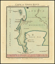
Rare First State of Sayer's Map of Table Bay
Scarce chart of Table Bay and the Cape of Good Hope, published by Robert Sayer.
The route of the Salt River is shown entering the bay just to the east of Cape Town, which is shown in detail with the fort, Company Gardens and the Gallows highlighted. Table Mountain is shown, flanked by Devil's Mount and Lyon's Mount.
In the bay the Anchoring Ground and Robben Island are surrounded by soundings and to the top left there is an inset engraving of A South View Of The Cape by Monsieur L'Abbé de la Caille.
While the later Sayer & Bennett and Laurie & Whittle editions appear on occasion, this first edition is very rare.
The chart includes a central compass rose oriented north to the left and there are two scales in Dutch miles and sea leagues.
The map is drawn from Joannes Van Keulen's earlier chart of 1753, published in the so-called Secret Atlas.
Robert Laurie (ca. 1755-1836) and James Whittle (1757-1818) formed their Fleet Street, London-based firm upon the 1794 death of their employer Robert Sayer, himself one of the dominant print and mapmakers of the last half of the 18th century.
Laurie & Whittle started managing Sayer's business as early as 1787. They took over all managerial duties when Sayer's health flagged in 1792, and they changed the imprint in 1794 upon his death. Sayer left the two a 21-year lease on the shop (at £100 a year) and on Sayer's Bolt Court premises, as well as an option to acquire stock and equipment at a preferential price of £5,000 payable over three years.
Robert Laurie retired from the firm in 1812, and his role was assumed by his son, Richard Holmes Laurie (1777-1858). The younger Laurie worked with James Whittle until the latter died in 1818. After R. H. Laurie died in 1858, Alexander George Findlay, FRGS (1812-1875) purchased the firm from his daughters. The firm continues today under another name, specializing in yachting charts.
Laurie & Whittle were prolific print and map publishers, and throughout their careers, they produced numerous very important and rare works. They carried on Robert Sayer's atlas business and were responsible for editions of The Complete East-India Pilot and The American Atlas.
![[Luanda, Angola] Eroberung der Statt Loando de Sanct Paolo in Angola in Africa. Gelegen](https://storage.googleapis.com/raremaps/img/small/85194.jpg)