|
||

|

|
|

|
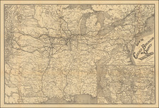
GW & CB Colton's First US-Centric Coast To Coast Map of the United States
Fine large map of the United States, published in New York By GW & CB Colton.
The map provides a marvelous overview of the United States, at a moment in time when the country's focus was shifting away from the Civil War and toward the impending completion of the Transcontinental Railroad, finally linking the two American coasts by rail.
The map illustrates the final iteration of how commercial mapmakers perceived the United States for purposes of constructing a large scale commercial map. While earlier maps of "only" the United States tended to focus first on the region east of the Mississippi River and later on the region east of the Rocky Mountains, virtually all maps "of the United States" which extended to the Pacific Ocean tended to include most or all of Mexico and large parts of Canada. Almost certainly, the impetus for change was the Transcontinental Railroad. While earlier large format maps had no particular need to provide significant detail on the regions between the Mississippi River and the Pacific Coast, once the country could be traversed by rail, there was simply no reason to devote significant space and effort engraving large scales maps that treated Mexico and Canada on a similar scale, hence the "British provinces, Mexico and the West Indies" have been dropped both from the map's title and its geographical coverage.
The map is a veritable tour de force of cartographic detail west of the Mississippi River. It treatment of the progress of the Northern, Central and Southern transcontinental railroad lines is exceptional, as its meticulous accounting of the military explorations in the west, illustrating the overland routes throughout the west forged by Fremont, Emory, Albert & Peck, Woodruff, Mullan, Donelson, Stansbury, Gunnsion, Simpson, Whipple, Parke and others.
The map includes eight vignette scenes around or within the decorative floral border, and a large inset map at lower left, "United States of America Showing Isothermal Lines and Zones of Equal Average Temperature."
The map shows the nearly-evolved boundaries of western states and territories, with the major unfinished delineation being Dakota and Wyoming attached as one; the proposed and nearly completed rail lines across the plains are shown, as are explorers' routes, recent forts, and much comment about the country.
The Gold Region of Colorado is prominently shown.
Rarity
The map is very rare. We have been unable to track another example of the map in any institutional collection.
Provenance: Warren Heckrotte Sale at PBA Galleries.
G. W. & C. B. Colton was a prominent family firm of mapmakers who were leaders in the American map trade in the nineteenth century. The business was founded by Joseph Hutchins Colton (1800-1893) who bought copyrights to existing maps and oversaw their production. By the 1850s, their output had expanded to include original maps, guidebooks, atlases, and railroad maps. Joseph was succeeded by his sons, George Woolworth (1827-1901) and Charles B. Colton (1831-1916). The firm was renamed G. W. & C. B. Colton as a result. George is thought responsible for their best-known work, the General Atlas, originally published under that title in 1857. In 1898, the brothers merged their business and the firm became Colton, Ohman, & Co., which operated until 1901, when August R. Ohman took on the business alone and dropped the Colton name.

![[ United States ] Etats-Unis de l'Amerique](https://storage.googleapis.com/raremaps/img/small/98821.jpg)
![[Los Angeles Olympic] O Limp Hicks Loose Anglaise Calif. 1932](https://storage.googleapis.com/raremaps/img/small/90509.jpg)