


|
||

|

|
|

|
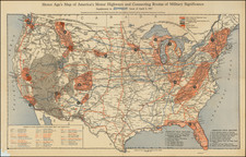
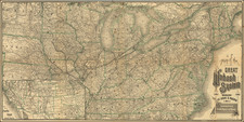
Fine early wall map of the United States, published shortly after the Kansas-Nebraska Act of 1854.
Extending from Coast to Coast, the map is of greatest interest for its depiction of the Western States and Territories shortly after the creation of Kansas.
- Massive Minnesota Territory, covering much of the Dakotas
- Nebraska extends to the Rocky Mountains and the Canadian Border
- Oregon & Washington extend to the Rocky Mountains
- New Mexico Territory and Utah Territory extend from California to the Rocky Mountains.
The west is filled with Indian Tribes, early forts, and the major wagon roads. The map makes and excellent attempt to depict the earliest Western Counties.
Kansas Nebraska Act
The Kansas-Nebraska Act was an 1854 bill that mandated “popular sovereignty”–allowing settlers of a territory to decide whether slavery would be allowed within a new state’s borders. The bill was proposed by Stephen A. Douglas, Abraham Lincoln’s opponent in the influential Lincoln-Douglas debates and overturned the Missouri Compromise’s use of latitude as the boundary between slave and free territory. The conflicts that arose between pro-slavery and anti-slavery settlers in the aftermath of the act’s passage led to the period of violence known as Bleeding Kansas, and the American Civil War (1861-65).
This 1854 bill to organize western territories became part of the political whirlwind of sectionalism and railroad building, splitting two major political parties and helping to create another, as well as worsening North-South relations.
The act passed Congress, but it failed in its purposes. By the time Kansas was admitted to statehood in 1861, southern states had begun to secede from the Union. The Independent Democrats and many northern Whigs abandoned their affiliations for the new antislavery Republican party, leaving southern Whigs without party links and creating an issue over which the already deeply divided Democrats would split even more. The railroad was eventually built but not along the route Douglas wanted and with funds voted by a Republican Congress during a Republican Civil War administration.
Rarity
This is the third state of the map, which was first published in 1854 and again in 1855 and later by J.G. Wells, New York. Mack R. Barnitz, Cincinnati, Ohio.
All states of the map are rare, especially in nice condition.
Alvin Jewett Johnson (1827 - 1884) was an American map publisher. Born in Wallingford, Vermont, he received only a basic public education, but he still served as a school teacher for several years before moving to Richmond, Virginia and, in 1857, New York City. Johnson also worked as a book canvasser for the map publisher J.H. Colton.
Johnson's name first appears on maps published with Samuel N. Gaston and D. Griffing Johnson (no clear relation) in the mid-1850s, and his name (along with Ross Browning) appeared on Colton's atlas maps of 1859 and 1860. Although map historian Water Ristow speculates that Colton sold his copyrights to Johnson and his business partner, fellow Vermonter Browning, a more likely theory is that Johnson and Browning financially bailed out the Colton firm in exchange for the right to use Colton’s existing copyrighted map plates. The first Johnson maps were mostly reissues of earlier Colton maps. Indeed, Johnson's earliest works described his firm as the “Successors to J. H. Colton and Company”. Johnson converted the original Colton steel plate engravings to lithographic stones, allowing his firm to produce more maps at a lower price point.
In 1860, the Johnson firm published its first significant work, the Johnson’s New Illustrated (Steel Plate) Family Atlas. The first edition of the Atlas bears imprints in both New York and Richmond, VA. In 1861, however, following the outbreak of the American Civil War, the Johnson & Browning firm abandoned their Richmond location. Browning seems to have remained in Virginia to pursue other ventures and, in 1861, Browning’s portion of the firm was purchased by Benjamin P. Ward. The 1863 issue of the Atlas was one of the most unusual, it being a compilation of older Johnson and Browning maps, updated 1862 Johnson and Ward maps, and newer 1863 maps with a revised border design.
The 1864 issue of the Atlas is the first true Johnson and Ward atlas. Johnson published one more edition in partnership with Ward in 1865, after which Johnson becomes the sole publisher. The next issue of the Atlas, 1866, is the first purely Johnson atlas with all new map plates, updated imprints, and copyrights. Johnson maps include a unique border style, which changed over the years, but was not copied by other makers. These include a “strapwork border” from 1860 to 1863, a “fretwork border” from 1863 to 1869 and a “spirograph border” in 1870.
In addition to the Family Atlas, Johnson issued numerous wall maps, pocket maps, and, in the 1880s, the Cyclopedia. Johnson frequently updated his western atlas maps and on occasion, more than one update appeared in a single year. Johnson continued to publish the Family Atlas until 1887. In 1879, Johnson brought his son into the business, and their publications have the imprint “A.J. Johnson and Son” and, later, “A.J. Johnson and Co.” Johnson’s son continued the business until it shuttered in 1887.