
The item illustrated and described below is sold, but we
have another example in stock. To view the example which
is currently being offered for sale, click the
"View Details" button below.
1881 -1883 Smith S. Leach / Edward Molitor
$ 4,500.00
Stock# 65714
Description
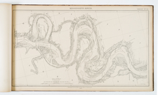
An attractive and scarce mapping of the lower Mississippi River starting at the Ohio River in the north and going to the Mississipi Delta in the south.
Depicts cotton fields, roads, canebrakes, levees, Indian mounds, and much more.
Condition Description
Oblong folio. Contemporary black half calf over cloth boards, gilt-tooled title piece on the front cover "Lower Mississippi River 1881-83". Backstrip and corners worn. Bookplate of the John Crerar Library, Chicago, on the front pastedown, with deaccession stamp from the University of Chicago. Title, table of distances, overview map in three sheets, and 32 sheets (i.e. complete). Some chipping to the edges of sheets not affecting the images.
Reference
Phillips Maps, page 442