|
||

|

|
|

|
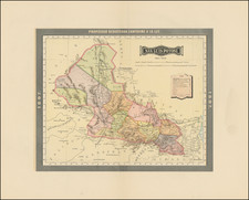
Mapping The Route From Veracruz to Puebla in the 18th Century
Finely executed manuscript map of the region between Veracruz and Puebla, highlighting the Camino Real, drawn during in the late 18th Century.
The map is meticulously constructed, showing dozens of towns and cities along the route. Various simples are used to indicate the size of the towns and cities, with a symbol for fortifications shown. Includes topographical information, including mountains and rivers. Roads are shown in brown, with rivers in blue. At least one "venta" (Inn) is shown along the Camino Real.
The map depicts the "Camino Real" between Puebla de los Angeles and Veracruz. At the time the map was drawn, this was a highly contested road because of the connection to the port of Veracruz. The merchants in Cordoba and Orizaba (at the bottom right of the map) eventually had the royal road to go through their cities.
Interestingly, the map maker made cities of Cordoba and Orizaba appear as minor towns far from all the amenities that the road provided. This suggests the map was done to serve the interests of the merchants from Jalapa, who were attempting to preserve the importance of their city on the Camino Real.
Fortaleza de San Carlos de Perote
The map notes the fortress S. Carlos. This is the Fortaleza de San Carlos de Perote, which was constructed as a defense against the perceived threat of English invasion via Veracruz after the English seizure of Havana, Cuba. The threat posed by the taking of Havana by the English in 1762 motivated Mexico Viceroy Joaquin de Montserrat to request the support of the Spanish Crown to organize the defense against an imminent attack that never occurred; San Juan de Ulúa was fortified on the coast, and further inland another fortress was ordered to be built which would defend against the taking of cities such as Puebla and Mexico City.
A year after the invasion of Havana, Brigadier de Ingenieros Manuel de Santiesteban arrived in Veracruz, to improve the fortifications of the port and interior routes to Puebla and Mexico City. For the defense of the Camino Real, he chose the plain north of Cofre mountain, 30 miles west of Xalapa, near the town of Perote. The building took seven years to build and was completed in 1777 by Viceroy Antonio María de Bucareli y Ursúa.
Rarity
While the map is unsigned, it is a fascinating artifact from the Mexican Colonial Period.

![Amer. Sep. No. 70. Partie Du Mexique [Acapulco]](https://storage.googleapis.com/raremaps/img/small/96401.jpg)