|
||

|

|
|

|
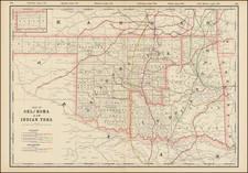
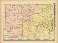
The Only Printed Map of The Proposed State of Sequoyah
Rare privately issued map of the State of Sequoya, prepared by D.W. Bolich, Civil Engineer, Muskogee, Indian Territory, in connection with the Sequoyah Statehood Convention of August and September 1905.
Sequoyah was the eastern half of the state of Oklahoma. Sequoyah was the remnant of what first became Indian Territory in 1830. The region west of the 95th parallel was used to relocate Eastern Indians who were an inconvenience to settlers wanting their lands. By the 1850s, Indian Territory was reduced to the area now known as Oklahoma and governed by the so called 5 Civilized Tribes, the Choctaw, Cherokee, Chickasaw, Creek, and Seminole. While there was no unified government, the Indians were allowed self governance.
In 1866, the Western portion of Indian Territory was taken by the United States to relocate additional tribes and as a punishment for supporting the south during the war. The Osage, the Arapaho, the Cheyenne, the Wichita, the Kiowa, and the Comanche were, part of the new groups. In 1889, some of the unassigned lands were opened to white settlers, resulting in the organization of the Territory of Oklahoma in the western portion in 1890.
Between 1887 and 1901, the United States Government reduced self governance and tribal influence and moved the region toward statehood. The eastern portion of the state conducted a constitutional convention in 1905 for the purpose of becoming a state, but the United States insisted upon only one state.
The proposed state of Sequoyah received its name from the great Cherokee statesman and inventor of a written form for the Cherokee language. Sequoyah worked to create a united government among Cherokee tribal factions upon their relocation to Indian Territory in 1839. The central feature of the Great Seal of the State of Sequoyah is a five-pointed star containing symbols of the Five Civilized Tribes: (clockwise) a sheaf of wheat and a plow for the Creek Nation, a village beside a lake with an Indian paddling a canoe for the Seminole Nation, a standing Indian Warrior for the Chickasaw Nation, a tomahawk, bow, and three crossed arrows for the Choctaw Nation, and a seven-pointed star within a wreath of oak leaves for the Cherokee Nation. Above the main star is a portrait of Sequoyah holding a tablet, inscribed "We are brethren," in Cherokee. The surrounding forty-six smaller stars represent the forty-five states of the Union, with an additional star for the State of Sequoyah.
Oklahoma entered the Union officially in 1907 and, as the Indians feared, it absorbed the remains of Indian Territory in the process. At that time, Oklahoma retained the names of 20 of the 48 counties from the State of Sequoyah, including the county of Sequoyah on the eastern border. Ironically, although the state of Sequoyah never materialized, much of the structure and many of the ideas laid out in their proposed constitution found their way into the newly formed charter of the state of Oklahoma.
This is the only obtainable map of the proposed state of Sequoyah.